




Colmar Tourist Map: Image and PDF
Both formats provide an overview of Colmar Old Town, showing its streets, historic monuments, picturesque squares, and canal-side neighborhoods.
Colmar Tourist Map Image
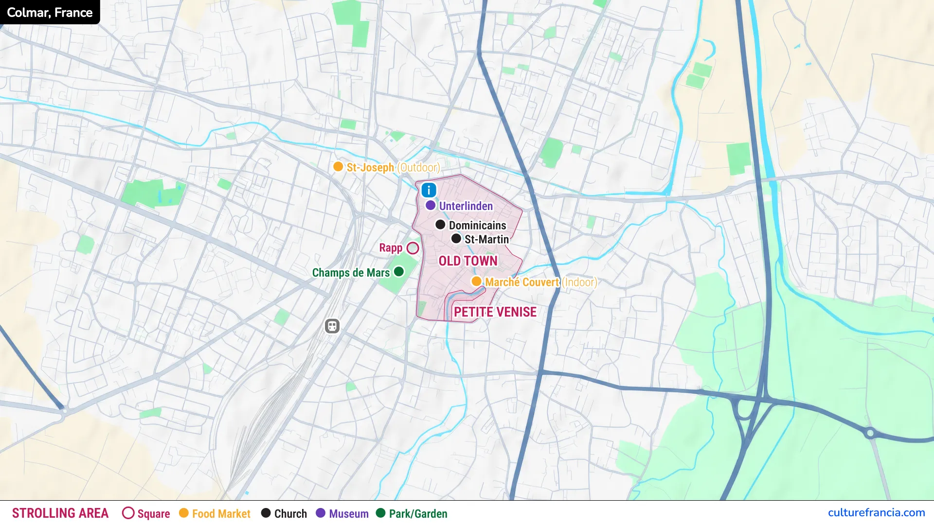
The image map is ideal for quickly locating Colmar’s main attractions. It covers the historic center, from the Unterlinden Museum in the north to the canals of Little Venice in the south.
You can save the image on your smartphone to consult it while exploring the city, without repeatedly searching for individual locations.
Colmar Tourist Map PDF
Open the Colmar Tourist Map PDF
For travelers who prefer a traditional city plan, the PDF map is the most practical format to download and print.
Keep a copy on your phone for offline reference, or print it before your visit. It is particularly useful for following pedestrian streets, identifying landmarks, and marking the places you want to discover.
Interactive Colmar Tourist Map

Click on the icon  in the top-right corner to view the map in full screen.
Show/Hide layers as needed.
After clicking on the image,
click on the icon  in the top-left corner to display the map legend.
Show/Hide layers as needed.
Our interactive map is the most convenient option for navigating between Colmar’s attractions. You can zoom in to identify individual streets, squares, and monuments, or zoom out to understand the layout of the historic center.
It is especially useful for locating the museums, exploring the old merchant quarter, and finding your way towards Little Venice.
Top Attractions on the Colmar Map
Colmar’s principal sights are concentrated within its historic center. Here are the places we recommend identifying on your map:
- Unterlinden Museum: Housed partly in a former convent, this remarkable museum is particularly famous for the Isenheim Altarpiece.
- House of Heads: An extraordinary Renaissance residence whose façade features more than a hundred sculpted faces.
- Saint Martin’s Church: The imposing Gothic church dominating the heart of Colmar’s Old Town.
- Pfister House: A beautifully decorated 16th-century residence on Rue des Marchands, distinguished by its painted façades and architectural details.
- Koïfhus (Old Customs House): A historic building on Place de l’Ancienne Douane, once central to the city’s commercial activities.
- Tanners’ Quarter and Covered Market: Traditional tall, half-timbered houses and a historic market building near the Lauch River.
- Little Venice and the Fishmongers’ District: Picturesque canals, colorful houses, and charming bridges offering some of Colmar’s most photographed views.
Colmar Walking Map: Suggested Route
We recommend starting your walking tour at the Unterlinden Museum and finishing in Little Venice.
From the museum, head towards the House of Heads, then continue to Saint Martin’s Church and the Pfister House. Walk through Place de l’Ancienne Douane to admire the Koïfhus before exploring the Tanners’ Quarter.
Continue towards the Covered Market and Quai de la Poissonnerie, ending among the canals and half-timbered houses of Little Venice.
Allow at least two hours for this itinerary, with additional time for museum visits, photographs, and leisurely stops.
Practical Map: Train Station, Parking and Tourist Office
Colmar train station lies southwest of the historic center, approximately 15 to 20 minutes away on foot.
If arriving by car, we recommend parking near the Old Town and exploring the center on foot, since many historic streets are pedestrianized.
The Colmar Tourist Office is located at Place Unterlinden, close to the museum, making it a convenient reference point on your Colmar city map.