




Marseille Tourist Map: Image and PDF Versions
View the Marseille Tourist Map Image
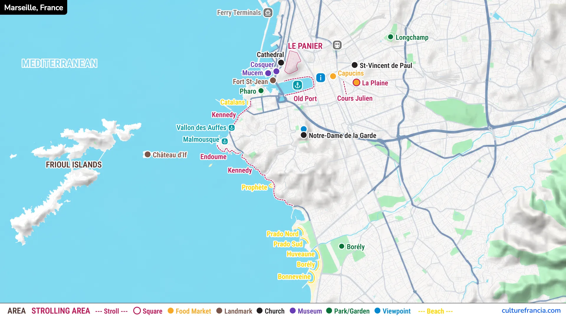
The image version is the quickest way to get your bearings. Start with the Old Port, the natural reference point for most first-time visits, then look north toward Le Panier and the Mucem, east toward Cours Julien, and south toward Notre-Dame de la Garde and the Corniche.
The colors and symbols distinguish museums, churches, viewpoints, food markets, parks and gardens, beaches, landmarks, and the areas that are especially pleasant for strolling.
For a first day in Marseille, this overview is often more useful than a conventional street map. It shows how the main sightseeing areas relate to one another, while making clear that Château d’If and the Frioul Islands sit offshore and require a boat trip.
Download the Marseille Tourist Map PDF
Open the Marseille Tourist Map PDF
If you prefer to plan ahead or keep a map available without relying on mobile data, download the Marseille tourist map PDF before your trip. It works well on a phone, tablet, or laptop, and you can print it if you prefer navigating with paper in hand.
Save it before leaving your hotel, take a screenshot of the area you are visiting, or print a copy and mark your route.
The PDF is best for offline orientation rather than turn-by-turn navigation. For exact streets, live public transport information, opening times, or the fastest route between two places, combine it with the interactive map or a navigation app.
Interactive Marseille Tourist Map

Click on the icon  in the top-right corner to view the map in full screen.
Show/Hide layers as needed.
After clicking on the image,
click on the icon  in the top-left corner to display the map legend.
Show/Hide layers as needed.
The interactive Marseille tourist map is the best option when you want to move from overview to detail. Use it to zoom in on attractions, understand distances, and decide what can realistically be grouped into the same outing.
That matters in Marseille. Two places can look close on a flat map while a steep climb makes the walk more demanding than expected. Notre-Dame de la Garde is the classic example: geographically central, but perched high above the city.
The interactive version is also useful when choosing between walking and public transport. Organize Marseille by areas rather than collecting attractions one by one. You will spend less time crossing the city unnecessarily.
How to Read Our Marseille Tourist Map
Our Marseille map is designed around travel decisions rather than administrative boundaries. The legend identifies the places most useful to visitors:
- Strolling areas highlight neighborhoods and streets where wandering is part of the experience.
- Museums and landmarks point toward major cultural and historical sights.
- Churches and viewpoints identify monuments and places with rewarding panoramas.
- Food markets and squares show lively areas where the city feels most local.
- Parks and gardens provide quieter breaks from the dense center.
- Beaches trace the Mediterranean side of Marseille, from Catalans toward Prado and Bonneveine.
The coastline is central to the map because Marseille makes far more sense when you see it as a Mediterranean port city rather than simply a large French city.
Top Attractions on the Marseille Tourist Map
Old Port, Le Panier, Marseille Cathedral, Mucem, and Fort Saint-Jean
If you have only a few hours, begin here. The Old Port is the most useful starting point for sightseeing in central Marseille, framed by boats, historic streets, waterfront life, and the city rising behind it.
From the northern side of the harbor, walk toward Le Panier. Narrow lanes, little squares, staircases, colorful façades, and sudden views toward the port make it ideal for slow exploration. Le Panier is less about ticking off monuments than enjoying the neighborhood itself.
Continue toward Marseille Cathedral, then the Mucem and Fort Saint-Jean. This compact area combines history, architecture, culture, and Mediterranean views without requiring transport.
Notre-Dame de la Garde and Marseille’s Best Viewpoints
Notre-Dame de la Garde watches over Marseille from its hilltop, and locals call it the Bonne Mère. For a first visit, this is the viewpoint we would not skip. From the terraces, the city spreads out below with the Old Port, urban neighborhoods, sea, and islands in one sweep.
The climb can be tiring, especially in hot weather. Walk if you enjoy hills, or use public transport and save your legs for the rest of the day.
For another perspective, head to the Pharo near the entrance to the Old Port. It gives you a broad harbor view with much less effort than the Bonne Mère.
Corniche Kennedy, Vallon des Auffes, and the Seafront
South of the Old Port, Marseille opens toward the sea. The Corniche Kennedy follows the coast past rocky shorelines, little ports, beaches, and neighborhoods that feel calmer than the busy center.
Vallon des Auffes is the postcard stop. This tiny fishing harbor is one of the most atmospheric places along Marseille’s seafront, tucked below the road and framed by traditional boats and houses.
Continue through Malmousque and Endoume if you enjoy coastal wandering. Allow time to stop and simply follow the Mediterranean views.
Château d’If and the Frioul Islands
The islands off Marseille are part of the city’s character and one of the easiest ways to see its skyline from the sea.
Château d’If sits on its fortified island and is famous for its association with Alexandre Dumas and The Count of Monte Cristo. Choose Château d’If if history and the fortress are your priority.
The Frioul Islands offer rocky paths, small coves, clear water, and wide views back toward Marseille. Choose Frioul if you want more time outdoors and a break from city streets.
Best Areas of Marseille to Explore on Foot
Old Port and Le Panier
For first-time visitors, the Old Port and Le Panier form Marseille’s easiest and most rewarding walking combination. Distances are manageable, major sights are close together, and there is always something to see between stops.
Start at the water, climb into Le Panier, then descend toward the cathedral, Fort Saint-Jean, and Mucem. The route naturally alternates between narrow streets and broad sea views.
Wear comfortable shoes. Marseille’s slopes and stairways have a habit of appearing just when you thought the walk was flat.
Cours Julien, La Plaine, and Noailles
For a more contemporary and everyday Marseille, head inland. Cours Julien is the place for street art, cafés, independent shops, and a creative atmosphere. Nearby La Plaine adds a more residential rhythm.
Noailles and the Capucins area bring busy streets, food shops, market life, and Mediterranean influences. Rather than visiting for a single landmark, come here to feel Marseille at street level.
Corniche Kennedy, Malmousque, and Endoume
If central Marseille feels intense, walk toward the coast. The Corniche route is the best urban walk for sea views, and you can adapt its length to your energy.
Vallon des Auffes makes an obvious stopping point, while Malmousque and Endoume reward slower exploration. Small streets lead toward the water and the city starts to feel almost village-like in places.
Come for Marseille at a gentler pace, with the Mediterranean rarely out of sight.
Marseille Beaches, Parks, and Gardens on the Map
Catalans, Prophète, Prado, Borély, and Bonneveine Beaches
Marseille’s beaches are spread along the southern coastline rather than concentrated beside the Old Port. Catalans is the closest major beach to the city center, making it convenient for a quick swim.
Farther south, Prophète is a popular stop along the Corniche. Continue toward Prado for broader seaside spaces, then Borély and Bonneveine.
If swimming is a priority, plan the beach as a separate part of the day rather than squeezing it between central monuments.
Longchamp and Borély
For greenery, Marseille offers useful escapes from the dense center. Longchamp combines monumental architecture with gardens, making it a pleasant detour from central neighborhoods.
Borély, farther south near the coast, works naturally with a Prado or beach day. Its green spaces give you breathing room before or after time by the sea.
Both are reminders that Marseille is not only stone, traffic, port, and coastline.
Getting Around Marseille with the Map
Walking Between Marseille’s Main Attractions
Walking is the best way to experience the central neighborhoods, but Marseille is larger and hillier than many visitors expect. Walk within sightseeing clusters, then use transport between distant areas.
The Old Port, Le Panier, cathedral, Mucem, and Fort Saint-Jean fit naturally together. Cours Julien and Noailles can also be reached on foot from the center. Notre-Dame de la Garde is walkable, but the uphill section deserves respect.
Do not judge walking time by straight-line distance alone, especially when hills are involved.
Metro, Tram, Bus, and Ferry Connections
Marseille’s public transport network is useful for bridging the gaps between sightseeing areas. Metro and tram lines cover much of the central city, while buses become particularly useful for hillier or more coastal destinations.
Boats are part of the picture too. The sea is not an obstacle in Marseille, but another way of moving around it.
For live schedules and disruptions, check current transport information on the day. Use our tourist map for orientation, then switch to live navigation when you need the exact connection.
Which Marseille Map Should You Use?
Tourist Map vs Public Transport Map
A tourist map answers a simple question: what is worth seeing, and where is it? Use our Marseille tourist map when planning attractions, neighborhoods, viewpoints, beaches, and sightseeing routes.
A public transport map answers a different question: which line should you take? Keep one available when moving between areas, particularly if your day includes the southern coastline or places outside the central walking zone.
The two maps work best together rather than competing with each other.
Tourist Map vs Google Maps
Google Maps is excellent for exact addresses, live directions, opening times, and finding businesses nearby. What it does not always provide is a clear hierarchy for a first-time visitor.
Use the tourist map to decide what deserves your attention, then use Google Maps to reach it. That simple division keeps planning from becoming an endless collection of pins.
Our map gives you the shape of the visit. A navigation app handles the final streets.
Marseille Tourist Map FAQ
Can I Download a Free Marseille Tourist Map PDF?
Yes. You can use the downloadable Marseille tourist map PDF for free and save it to your phone, tablet, or computer before your visit.
It is designed for quick sightseeing orientation and includes major attractions, strolling areas, beaches, parks, museums, landmarks, viewpoints, and other visitor references.
What Are the Main Attractions to Mark on a Marseille Map?
For a first trip, mark the Old Port, Le Panier, Marseille Cathedral, Mucem, Fort Saint-Jean, Notre-Dame de la Garde, and Vallon des Auffes first. Together, they give you an excellent introduction to the city’s port, history, architecture, neighborhoods, and Mediterranean setting.
If you have more time, add Cours Julien, Château d’If, the Frioul Islands, Longchamp, the Corniche, and the Prado beaches.
Is Marseille Easy to Explore on Foot?
The historic center is very walkable, but Marseille as a whole is too large to cover comfortably on foot. The smartest approach is to walk by neighborhood and use public transport between distant zones.
Expect hills, stairs, and longer coastal distances than the map sometimes suggests. Comfortable shoes are a good idea if you plan to explore properly.
What Is the Best Area of Marseille for Sightseeing?
For most first-time visitors, the Old Port is the best base for sightseeing. It places you close to Le Panier, the Mucem, Fort Saint-Jean, the cathedral, Noailles, and transport connections to other parts of Marseille.
But the best Marseille experience does not stay around the port all day. Follow the map uphill to the Bonne Mère, south toward the Corniche, or out across the water to the islands. Marseille is at its best when the city and the Mediterranean share the itinerary.