




Nice Old Town Tourist Map
Image: Nice Old Town Tourist Map
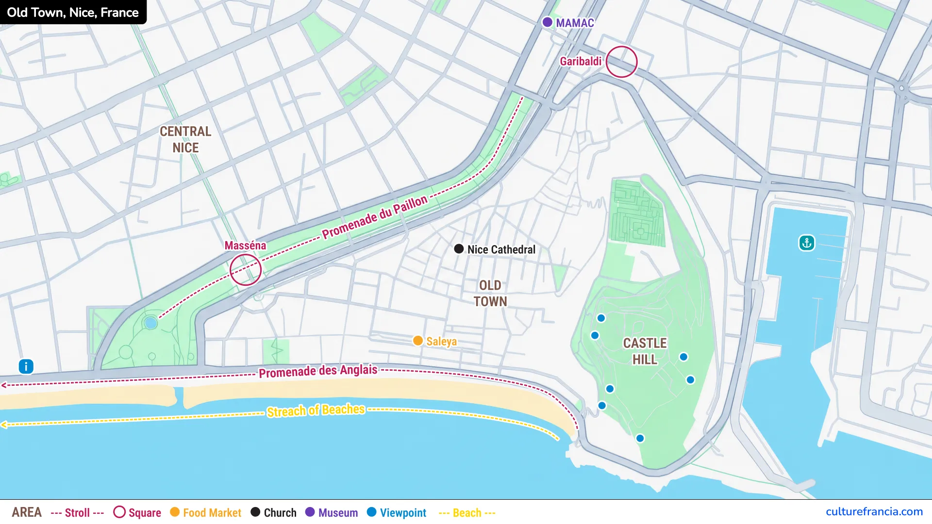
The image version gives you the historic quarter in one clear view. Use the Nice Old Town map image to locate the main squares, monuments and pedestrian streets before you start walking.
Vieux Nice is compact, but its narrow network of streets can make distances difficult to judge. A quick glance at the map is often enough to put you back on track.
PDF: Nice Old Town Tourist Map
Open the Nice Old Town Tourist Map PDF
The PDF version is designed for easy offline use. Open the Nice Old Town tourist map PDF if you want a printable map of Vieux Nice and its main attractions.
It is particularly handy if you prefer wandering without constant phone navigation. Mark Cours Saleya, Place Rossetti, Palais Lascaris and your route toward Castle Hill, then let the smaller streets provide the surprises.
Interactive: Nice Old Town Tourist Map

Click on the icon  in the top-right corner to view the map in full screen.
Show/Hide layers as needed.
After clicking on the image,
click on the icon  in the top-left corner to display the map legend.
Show/Hide layers as needed.
The interactive version is the most precise option. Use the interactive Vieux Nice map to zoom into individual streets, squares and attractions.
It is useful when looking for a particular church, museum or access point to Castle Hill. Zoom out occasionally, however. Old Nice is best understood as a compact neighborhood rather than a collection of isolated pins.
Other Nice Maps
Nice Tourist Map
For everything beyond the historic quarter, open our Nice Tourist Map.
It shows how Vieux Nice connects with Place Masséna, the Promenade des Anglais, Castle Hill, Port Lympia, Cimiez and the city’s other major visitor areas.
Use the Nice Old Town map for street-level detail and the Nice Tourist Map for the wider city. Switching between the two makes planning much easier.
Nice Old Town Map with Attractions and Landmarks
Cours Saleya
Cours Saleya is one of Vieux Nice’s main reference points, running just behind the seafront beneath the colorful façades of the old quarter.
Cours Saleya is the easiest southern anchor to identify on a Nice Old Town map. Its markets, café terraces and open space contrast sharply with the tight streets immediately behind it.
From here, you can slip north into the old lanes, walk toward Place Rossetti or reach the seafront in only moments.
Nice Cathedral
Cathédrale Sainte-Réparate stands on Place Rossetti and is one of the major Baroque landmarks of Vieux Nice.
Nice Cathedral and Place Rossetti form a natural central reference point inside the Old Town. The cathedral’s façade and dome emerge almost unexpectedly after the narrow surrounding streets.
If you are building a walking route, the cathedral fits naturally between the western part of Vieux Nice and Rue Droite.
Place Rossetti
Place Rossetti opens suddenly in the middle of a maze of lanes, framed by colorful Nice façades, terraces and Sainte-Réparate Cathedral.
Place Rossetti is one of the easiest places to reorient yourself in the heart of Vieux Nice. It is also one of the liveliest squares, especially later in the day.
Several useful walking routes branch from here, including streets leading toward Palais Lascaris and paths climbing in the direction of Castle Hill.
Palais Lascaris
Palais Lascaris stands on Rue Droite, one of the historic streets crossing the Old Town.
Behind its Baroque façade is a richly decorated former aristocratic residence, very different from the comparatively restrained exterior architecture found throughout much of Vieux Nice.
Locate Palais Lascaris if you want to add one important indoor cultural stop to an Old Town walk. Its position also makes Rue Droite a useful axis through the neighborhood.
Place du Palais de Justice
Place du Palais, usually identified by visitors with the Palais de Justice, is a broader and more formal space than most of the Old Town.
Use Place du Palais de Justice as a western reference point when navigating Vieux Nice. The neoclassical courthouse, terraces and surrounding façades give the square a distinctive atmosphere.
From here, Cours Saleya lies nearby, while streets such as Rue du Marché draw you deeper into the historic quarter.
Castle Hill
Castle Hill rises directly east of the Old Town and forms one of its clearest geographic boundaries.
Add Castle Hill to the end or beginning of your Vieux Nice walk for the best overview of the neighborhood. Several approaches connect the historic streets with the hill, while other access points can be found closer to the waterfront.
From above, you can look back across the Old Town roofs and Baie des Anges or toward Port Lympia on the opposite side.
Vieux Nice Map
Streets and Pedestrian Areas in Vieux Nice
The pleasure of Vieux Nice lies between the landmarks. Its narrow streets, passages and small changes of direction are part of the experience, not an obstacle to it.
Rue Droite is one of the useful north-south references, while Rue Rossetti leads toward the square and climbing routes near Castle Hill. Around them runs a dense web of smaller lanes.
We recommend using the map to maintain a general sense of direction without following it obsessively. Some of the best moments come when you turn into a quieter street simply because it looks inviting.
Squares and Markets in Nice Old Town
Vieux Nice repeatedly opens from narrow lanes into lively squares. Cours Saleya, Place Rossetti and Place du Palais are the three most useful open spaces to recognize on the map.
Cours Saleya is closely associated with its markets and morning activity. Place Rossetti is more intimate and sits around the cathedral, while Place du Palais has a grander architectural character.
Together, these spaces make excellent reference points for navigating the neighborhood.
Access to Castle Hill and the Seafront
The Old Town sits between Castle Hill and the Mediterranean, so both are easy additions to a walking route.
For the seafront, simply head south from Cours Saleya toward Quai des États-Unis. For Castle Hill, several approaches rise from the eastern side of Vieux Nice, with steeper walking routes available for those who prefer to climb.
This relationship is what makes the neighborhood so satisfying to explore. Within a short walk, you can move from shaded lanes to a colorful market, then emerge beside the sea or above the rooftops.
How to Use the Nice Old Town Tourist Map
Walking Around Nice Old Town
Vieux Nice is made for walking. Do not try to follow the shortest route between every attraction, because the streets themselves are one of the main reasons to visit.
We suggest choosing two or three fixed reference points, such as Cours Saleya, Place Rossetti and Palais Lascaris, then wandering naturally between them.
Early morning reveals a quieter Old Town, while later hours bring more activity to the squares and terraces. Either way, comfortable shoes are considerably more useful than a rigid itinerary.
Planning a Visit to Vieux Nice
For a compact visit, start around Cours Saleya, walk into the historic streets toward Place Rossetti and Sainte-Réparate Cathedral, then continue along Rue Droite to Palais Lascaris.
Finish around Castle Hill if you want to end with a panoramic view over Nice and the Mediterranean.
If you have more time, add Place du Palais de Justice and allow yourself detours through the smaller lanes rather than treating every minute as transit time.
Vieux Nice is compact enough to explore in a few hours, but rich enough to reward a much slower wander. Use this map for the details. When you are ready to continue toward Place Masséna, the Promenade des Anglais, Port Lympia or Cimiez, switch back to our Nice Tourist Map for the wider view.