




Antibes Tourist Map
The map covers the part of Antibes most visitors are likely to explore, from Fort Carré in the north to the Old Town, the seafront beaches and the northern section of Cap d’Antibes. Juan-les-Pins also appears to the west, making it easier to understand how the different parts of the destination fit together.
It is particularly useful if you are planning a day on foot. Old Antibes is compact, but the wider tourist area stretches well beyond the historic center, especially once you add the beaches and Cap d’Antibes.
Image: Antibes Tourist Map
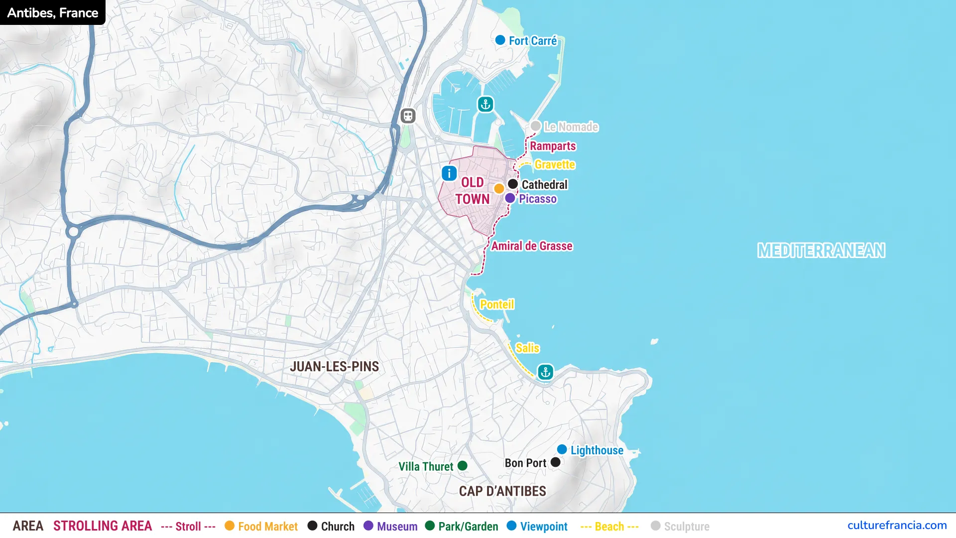
The image version is the quickest way to get your bearings. The Old Town is highlighted beside the sea, with the main cultural attractions clustered around its eastern edge. To the north are Port Vauban, Le Nomade and Fort Carré. South of the historic center, the coastline leads toward Ponteil and Salis beaches before reaching Cap d’Antibes.
Use the image first if you simply want to understand where the main attractions are in relation to one another. It makes the geography immediately readable without filling the map with every street name.
The color-coded symbols separate museums, churches, gardens, viewpoints, beaches and other landmarks. The strolling area and suggested coastal path also help you distinguish the compact sightseeing zone from places that require a longer walk.
PDF: Open the Antibes Tourist Map
Open the Antibes Tourist Map PDF
For trip planning, the PDF version is more practical. You can open it at full size, keep it on your phone or tablet, and consult it without having to navigate through several map layers.
The PDF is especially useful if you want a simple Antibes attractions map that can be checked quickly while walking. It shows the same key locations as the image, including Fort Carré, Le Nomade, the ramparts, Picasso Museum, the cathedral, Gravette, Ponteil and Salis beaches, Villa Thuret, Bon Port and the lighthouse.
It also works well as a printable Antibes map. Before leaving your accommodation, you can use it to choose which part of the city you want to focus on and avoid crossing the peninsula unnecessarily.
Interactive Antibes Tourist Map

Click on the icon  in the top-right corner to view the map in full screen.
Show/Hide layers as needed.
After clicking on the image,
click on the icon  in the top-left corner to display the map legend.
Show/Hide layers as needed.
The interactive Antibes map is the best option when you need precision rather than a general overview. Use it to zoom in on streets, check the exact position of an attraction and understand the route between two places.
This is particularly helpful around the Old Town, where a small number of streets contain several major sights, and around Cap d’Antibes, where the distances become less obvious on a simplified city map.
We recommend using both formats rather than choosing only one. Start with the static map to understand the overall layout, then switch to the interactive version when you need street-level detail. That combination is usually much quicker than trying to understand Antibes from a crowded general-purpose map.
How to Read the Antibes Tourist Map
Antibes is not difficult to navigate, but its tourist geography has several distinct parts. The Old Town forms the main sightseeing core. The port and Fort Carré lie immediately to the north, while the most accessible beaches and the road toward Cap d’Antibes continue south along the Mediterranean.
Juan-les-Pins sits on the other side of the peninsula. Seeing these areas together explains why a visit can feel compact in the morning and surprisingly spread out by the afternoon.
Strolling Area and Walking Route
The colored strolling area marks the historic heart of Antibes, where walking is not simply the easiest way to get around but part of the pleasure of the visit. Narrow streets, small squares, the market area and the seafront ramparts are packed into a relatively small space.
For a first visit, we recommend exploring Old Antibes almost entirely on foot. The streets around the cathedral and Picasso Museum reward slow wandering more than point-to-point navigation, and the ramparts give you an easy visual reference whenever you reach the sea.
The dotted route along the coast extends the experience beyond the Old Town. It follows the waterfront south past Amiral de Grasse and toward the beaches. If you have more time, continue in the direction of Ponteil and Salis rather than turning back immediately after the historic center.
Attraction Symbols and Map Legend
The legend is designed to make the map readable at a glance. Each color corresponds to a different type of place, so you can decide whether you want to prioritize art, heritage, gardens, viewpoints or beaches.
Museums are marked separately from churches, while parks and gardens have their own symbol. Viewpoints stand out along the coast and on Cap d’Antibes, and the beaches are traced directly along the shoreline. The food market symbol helps locate one of the liveliest parts of Old Antibes.
Rather than trying to show every possible attraction, the map concentrates on a manageable selection. That is useful in Antibes, where the best visit often comes from combining a few major sights with time to walk, stop by the sea and let the old streets do some of the work.
Attractions and Areas Shown on the Antibes Map
The main places on the map fall naturally into five zones. Read them from north to south and the structure of Antibes becomes simple: Fort Carré and the port, the Old Town, the beaches, Cap d’Antibes, then Juan-les-Pins on the western side.
Old Antibes: Picasso Museum, Cathedral and Ramparts
Old Antibes is the obvious starting point. The historic center occupies a compact wedge beside the Mediterranean, protected on the seaward side by surviving fortifications and threaded with narrow streets behind them.
The Picasso Museum is the cultural landmark to prioritize in the Old Town. It occupies the Château Grimaldi, a historic building set directly above the sea. The setting matters almost as much as the collection because the museum sits right beside the ramparts, where art, old stone and the Mediterranean come together in one of the most characteristic views of Antibes.
The nearby cathedral is easy to combine with the museum, while the seafront promenade along Amiral de Grasse provides a natural continuation. Do not rush it. The ramparts are one of the best places to understand how tightly the old city is pressed between its streets and the sea.
Port Vauban: Le Nomade and Fort Carré
North of the Old Town, the atmosphere changes quickly. The lanes give way to the vast space of Port Vauban, one of the defining features of the Antibes waterfront.
Le Nomade is the visual link between the old city and the port, a monumental openwork figure positioned beside the water. From this part of the harbor, the view back toward the ramparts is particularly effective because the historic city suddenly appears as a whole rather than as a maze of streets.
Continue north and Fort Carré becomes the dominant landmark. The star-shaped fortress stands above the harbor and recalls the long strategic importance of Antibes. It sits outside the compact Old Town, so allow extra time if you want to include it rather than treating it as a quick detour.
Antibes Beaches: Gravette, Ponteil and Salis
Antibes is unusual in allowing you to combine a historic-center visit with several beaches without leaving the urban area. Gravette is the most convenient beach for Old Antibes, tucked close to the ramparts and Port Vauban.
Farther south, Ponteil and Salis follow the coast in the direction of Cap d’Antibes. They are better choices if you want the beach to be a real part of the day rather than a brief stop between monuments.
Salis in particular marks the transition between central Antibes and the peninsula. The coast feels more open here, and the views help explain why Cap d’Antibes has such a different character from the dense historic center just to the north.
Cap d’Antibes: Lighthouse, Bon Port and Villa Thuret
Cap d’Antibes is where the map starts to stretch. This green peninsula separates Antibes from Juan-les-Pins and replaces the dense Old Town with villas, gardens, rocky coastline and longer distances.
The lighthouse area is one of the key orientation points on the Cap, close to the Garoupe heights and panoramic views over the surrounding coast. Bon Port lies nearby on the eastern side of the peninsula.
Villa Thuret appears farther west and inland. Its botanical garden adds a completely different stop to a day dominated by stone, sea and beaches. If your schedule is tight, do not try to cover the entire Cap on foot simply because it looks close on the map. Choose one or two places and give them time.
Juan-les-Pins and the Wider Antibes Area
Juan-les-Pins belongs to the same commune but faces the opposite side of the peninsula, opening onto a broad bay west of Cap d’Antibes. Its position on the map is important because Juan-les-Pins is not another neighborhood of the Old Town, but a distinct seaside center with its own atmosphere.
For sightseeing, Old Antibes generally deserves priority. For beaches, seafront life and a different Riviera mood, Juan-les-Pins can complement the historic city very well.
The useful thing about seeing both on one Antibes city map is perspective. What initially looks like a single resort is really a collection of contrasting areas: fortified streets and museums, a huge marina, urban beaches, a wooded peninsula and another seaside center beyond it. Once you understand that geography, planning Antibes becomes much simpler.