




Avignon Tourist Map: Image and PDF Versions
Avignon Tourist Map Image
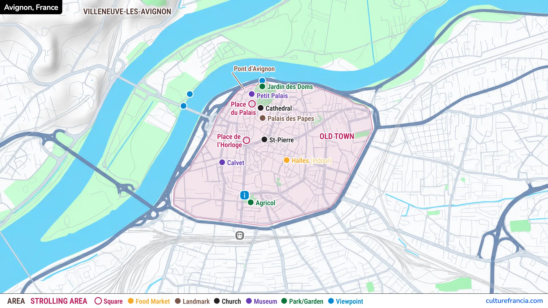
The image version is the quickest way to understand Avignon before you arrive. Save it on your phone and you have the essentials in one glance: the Palais des Papes, Pont d’Avignon, Jardin des Doms, Petit Palais, cathedral, Place de l’Horloge, Saint-Pierre, Musée Calvet, Les Halles, and Saint-Agricol. Avignon Tourist Map PDF
Use the image map for orientation and quick decisions while walking. It is deliberately simple, so you can see how the major attractions relate to one another without being buried under every street name.
The densest sightseeing zone lies in the north of the Old Town around Place du Palais. From there, many worthwhile stops spread south and east through the historic streets.
Avignon Tourist Map PDF
Open the Avignon Tourist Map PDF
The PDF version is better when you want a map you can print, keep offline, or open on a larger screen while planning the day. Download the Avignon tourist map PDF before leaving your hotel or accommodation if you prefer not to rely on mobile data.
A printed copy is also handy for marking a walking route, restaurant stop, museum, or meeting point. If you are visiting as a couple or family, it avoids the familiar scene of everyone crowding around one phone while somebody insists the palace is “definitely this way.”
For a short stay, the PDF and image versions contain enough information to build a very efficient sightseeing route.
Interactive Avignon Tourist Map

Click on the icon  in the top-right corner to view the map in full screen.
Show/Hide layers as needed.
After clicking on the image,
click on the icon  in the top-left corner to display the map legend.
Show/Hide layers as needed.
The interactive version comes into its own when the static map has done its job and you need street-level detail. Use the interactive Avignon map to zoom in, check exact locations, and move between individual points of interest.
It is especially useful when choosing a café between visits, locating an entrance, or deciding whether to add another museum before returning toward Place de l’Horloge.
How to Use the Interactive Map
Begin by identifying three anchors: Palais des Papes in the north, Place de l’Horloge just to the southwest, and Les Halles farther southeast. Once those are clear, Avignon becomes much easier to read.
Do not try to follow the map turn by turn all day. Avignon rewards small detours. Use the interactive map when you need it, then put the phone away for a while and follow the narrow streets, stone façades, little squares, and church towers.
If time is tight, pin your absolute priorities first. The palace and bridge deserve priority, while gardens, squares, churches, and market stops fit naturally around them.
What to See on the Avignon Tourist Map
Palais des Papes, Pont d’Avignon, and the Cathedral
The Palais des Papes is the obvious starting point. Seven popes succeeded one another in Avignon between 1309 and 1376, and the palace grew during the 14th century into the monumental complex that still dominates the city today. If you see only one historic monument in Avignon, make it the Palais des Papes.
Just beside it stands Avignon Cathedral, while the Petit Palais is only a few steps away. Keep these sights together on your itinerary rather than returning to the same neighborhood later in the day.
From here, head toward the famous Pont Saint-Bénézet, better known as the Pont d’Avignon. The surviving bridge reaches into the Rhône, and its riverside setting makes it one of the defining views of the city.
Museums, Squares, Les Halles, and Other Attractions
Place de l’Horloge is Avignon’s natural pause button. Cafés and terraces make it a convenient meeting point between visits, while the surrounding streets lead quickly back toward the palace or deeper into the Old Town.
Farther south, Musée Calvet adds an art stop to the route. Saint-Pierre and Saint-Agricol bring you back to the ecclesiastical side of Avignon, but on a smaller, more intimate scale than the papal complex.
For something more edible, make for Les Halles. The covered market brings together regional producers as well as places where you can stop for something to eat. Plan Les Halles around your appetite, not as an afterthought at the end of the day.
Jardin des Doms and the Best Viewpoints
Above the Rhône beside the cathedral, Jardin des Doms provides the green pause that this stone-heavy city needs. Come here for a break and for a broader sense of Avignon’s geography.
From the elevated area, the relationship between the city, Rhône, bridge, river islands, and Villeneuve-lès-Avignon becomes much clearer. It is a useful stop early in your visit if you like understanding a city from above before getting happily lost below.
The map also marks viewpoints near the Rhône. If the weather is kind, save at least one viewpoint for later in the day, when the softer light suits the old walls and river particularly well.
How to Explore Avignon with the Map
A Simple Walking Route Through Avignon Old Town
For a first visit, we recommend a north-to-south loop rather than trying to tick off sights in numerical order. Start at the Palais des Papes, see the cathedral and Jardin des Doms, continue to Pont d’Avignon, then return through Place de l’Horloge.
From there, wander toward Saint-Pierre and Les Halles. If museums are a priority, extend the route west toward Musée Calvet before looping back through the center.
This route keeps the grand monuments together, places the market around the middle of the day, and leaves room for unscheduled discoveries. Avignon is compact enough that a wrong turn is rarely a disaster. Sometimes it is the better route.
Understanding Avignon Old Town and the Rhône
The historic center sits inside the ramparts, with the Rhône forming the city’s great natural boundary to the north and west. Across the river lies Villeneuve-lès-Avignon, historically distinct from papal Avignon. The Rhône once marked a genuine political frontier between the two sides.
Think of the Old Town as your main walking zone and the river as your orientation line. When you know where the Rhône and Palais des Papes are, it becomes difficult to stay confused for long.
Avignon Centre station lies just south of the walls. Once you are inside the historic center, walking is the simplest way to connect the map’s central attractions and, frankly, much more pleasant than treating every short hop as a transport problem.
Which Avignon Map Should You Use?
Choose according to the moment. The image map is best for a fast overview, the PDF for printing and offline planning, and the interactive map for precise navigation. There is no reason to pick only one.
Before the trip, use the PDF or interactive map to build your route. During the visit, keep the image map handy for quick orientation and switch to the interactive version only when you need exact street detail.
For most first-time visitors, that combination is simpler than using a dense street map from morning to evening.
Avignon Tourist Map: Wrap-Up
Avignon is one of those cities where a good map quickly makes the place feel manageable. The main monuments cluster inside the ramparts, the Rhône gives the city a clear edge, and the papal quarter provides an obvious starting point.
Begin with the Palais des Papes, group nearby sights together, use Les Halles as a natural food stop, and leave time for Jardin des Doms and the Rhône viewpoints. With the image, PDF, and interactive Avignon tourist maps working together, you can spend less time navigating and more time enjoying the city.