




Strasbourg Tourist Map
Strasbourg City Map
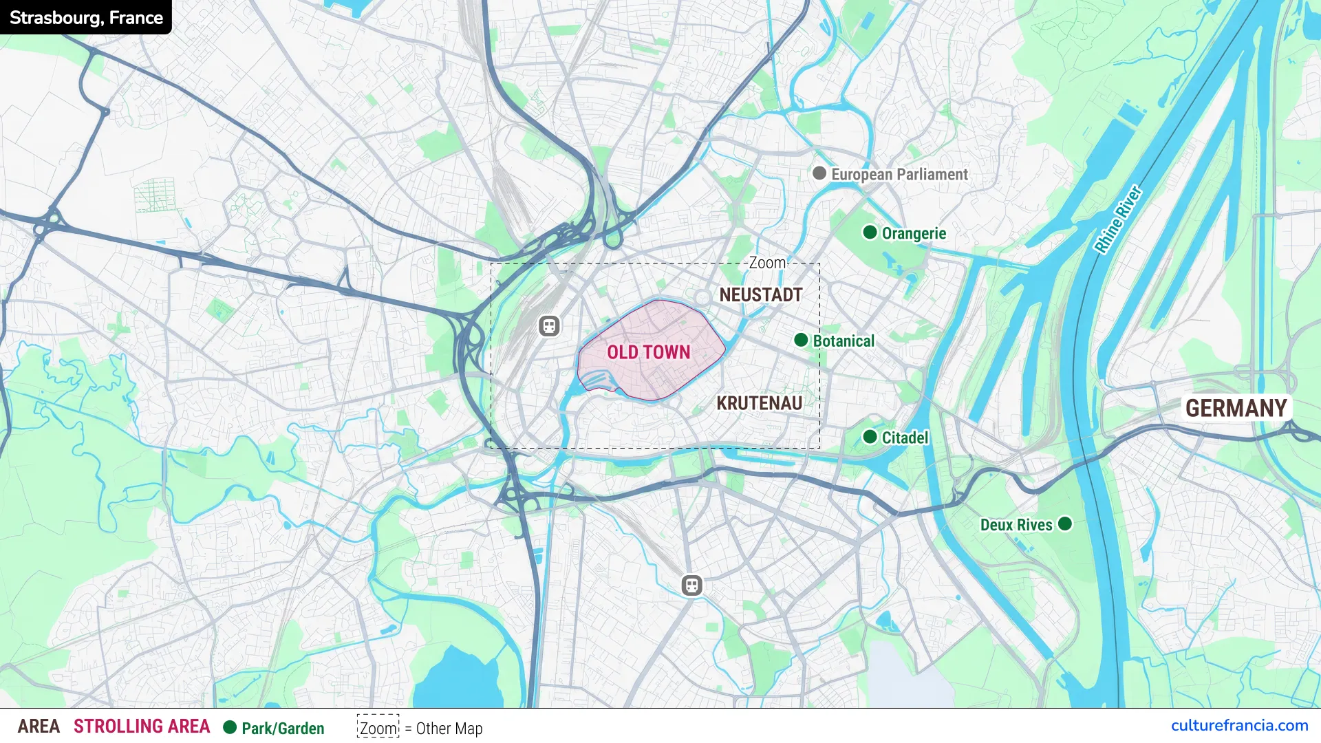
The general Strasbourg city map is the best place to start. It shows how the Old Town fits into the wider city, with Neustadt to the northeast, Krutenau to the southeast, and the Rhine marking Strasbourg’s eastern edge before Germany.
It also locates the European Parliament, Parc de l’Orangerie, the Botanical Garden, the Citadel and Deux Rives. At a glance, you can see which sights belong to the compact center and which are better reached by a longer walk, bicycle or tram.
Strasbourg Tourist Map PDF
Open the Strasbourg Tourist Map PDF
Download the Strasbourg tourist map PDF for a simple city overview that works without an internet connection. Keep it on your phone, tablet or print it before sightseeing.
The PDF is designed for orientation rather than street-by-street navigation. We recommend using it to understand the main tourist areas, then changing to the detailed Old Town map once you enter the historic center.
Strasbourg Old Town Tourist Map
Strasbourg Old Town Map
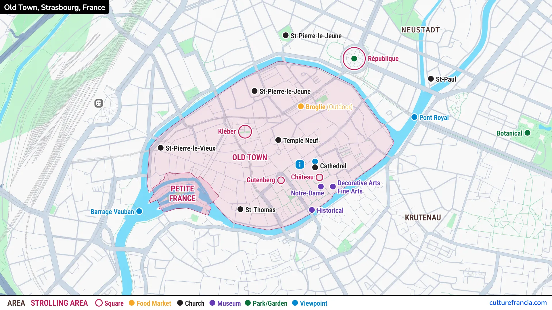
The Strasbourg Old Town map zooms in on the area where most first-time visitors spend the greatest amount of time. The historic core is centered on the Grande Île, with the cathedral toward its eastern side and Petite France in the southwest. The Ill wraps around the island, making the center surprisingly easy to understand once you see its shape.
The map identifies Place Kléber, Place Gutenberg, Place du Château, Strasbourg Cathedral, St Thomas Church, Temple Neuf, museums and Barrage Vauban. Most of these sights can be connected comfortably on foot.
Strasbourg Old Town Map PDF
Open the Strasbourg Old Town Tourist Map PDF
For a walking day, the Strasbourg Old Town map PDF is the most useful version to save or print. It removes the wider city from view and concentrates on the streets, squares and landmarks you are most likely to link on foot.
Keep it handy between the cathedral, Petite France and the main squares. It also gives you enough orientation to wander into smaller streets without feeling tied to a fixed itinerary.
Interactive Strasbourg Tourist Map

Click on the icon  in the top-right corner to view the map in full screen.
Show/Hide layers as needed.
After clicking on the image,
click on the icon  in the top-left corner to display the map legend.
Show/Hide layers as needed.
An interactive Strasbourg tourist map becomes useful when you move from planning to precise navigation. Use it to locate individual sights, check your route and move easily between the Old Town and attractions farther from the center.
Our preferred approach is to combine formats. The city map explains Strasbourg’s geography, the Old Town map makes the historic center easy to visualize, and the interactive map handles exact directions while you are moving around.
Main Areas on the Strasbourg Tourist Map
Old Town and Grande Île
The Grande Île is Strasbourg’s historic heart and the natural starting point for a first visit. Surrounded by branches of the Ill, it contains the cathedral, major squares, old streets and museums.
The area is compact enough to explore on foot, and the cathedral spire is a useful visual landmark. The Grande Île and the neighboring Neustadt together form Strasbourg’s UNESCO-listed urban ensemble.
Petite France
At the southwest corner of the historic center, Petite France is the most picturesque section of the Old Town, where channels of the Ill wind around old houses, bridges and former working quarters.
It combines naturally with Barrage Vauban and the Covered Bridges. For a calmer look at the narrow lanes and waterside façades, earlier hours are particularly pleasant.
Neustadt
Cross northeast from the Grande Île and the city changes character. Neustadt is the former imperial German district, built around broad avenues, monumental buildings and architecture very different from the tighter streets of the Old Town.
Place de la République is the easiest reference point. From here, you can continue toward St Paul Church, the university area or the European Quarter.
Krutenau and the European Quarter
South-east of the historic center, Krutenau forms a natural transition between the Old Town and the university area, with a livelier, more everyday atmosphere than the monumental center.
Farther northeast, the European Quarter is more spacious. The European Parliament and other European institutions stand near Parc de l’Orangerie, so the general city map is more useful here than the Old Town version.
Orangerie, Deux Rives and the Rhine
Parc de l’Orangerie is the major green landmark east of the center, while Deux Rives stretches toward the Rhine and Kehl in Germany. These areas reveal a more open, contemporary side of Strasbourg.
They sit beyond the main Old Town walking circuit, so it is better to plan them as a separate part of the day rather than tack them onto a short historic-center stroll.
Main Attractions on the Strasbourg Tourist Map
Strasbourg Cathedral
Strasbourg Cathedral is the key landmark for both sightseeing and orientation. Its position near the eastern side of the Grande Île makes it an obvious starting point for exploring the Old Town.
Place du Château and several museums are immediately nearby, with Place Gutenberg just to the west. From here, you can continue across the island toward Petite France.
Squares and Churches
Strasbourg’s squares help give structure to a walking route. Place Kléber is the main central reference point, while Place Gutenberg and Place du Château lead naturally toward the cathedral.
Churches provide further markers: St Thomas lies toward the south, Temple Neuf occupies a central position, and St Pierre-le-Jeune is farther north. Use them as waypoints rather than isolated stops.
Museums
Several museums are grouped around the cathedral and Place du Château. If museums are a priority, this is the easiest part of Strasbourg to organize efficiently, since important collections sit within a very small area.
The Historical Museum is also nearby on the southern side of the center. Leave enough time outside, however, because Strasbourg’s streets, canals and architecture are part of the experience.
Parks and Viewpoints
Barrage Vauban is the key viewpoint beside Petite France, while the Botanical Garden and Parc de l’Orangerie provide larger green spaces east and northeast of the center.
Do not try to force them into one circuit. Combine Barrage Vauban with the Old Town, then treat the gardens and parks as part of a wider itinerary through Neustadt or the European Quarter.
How to Use the Strasbourg Tourist Map
Planning a Walking Route Through Strasbourg
For a first visit, start around the cathedral, cross the Grande Île toward Petite France, then return through the central streets and squares. This creates a logical loop and avoids repeatedly retracing your steps.
If you have more time, add Neustadt after the Old Town. We recommend keeping the European Quarter, Orangerie and Deux Rives for a second stage of the visit because they lie beyond the dense cluster of central sights.
Using the Maps on Mobile or Offline
Save the PDFs before you leave Wi-Fi, especially if you want a reliable backup while walking. A printable Strasbourg tourist map is also handy for groups who do not want to depend on a single phone.
Use the static maps for the big picture and the interactive version for exact directions. In Strasbourg, that combination works particularly well: the center is compact, while the wider city becomes easier once you can switch between overview and detailed navigation.