




Choose Your Nîmes Tourist Map
Nîmes Tourist Map Image
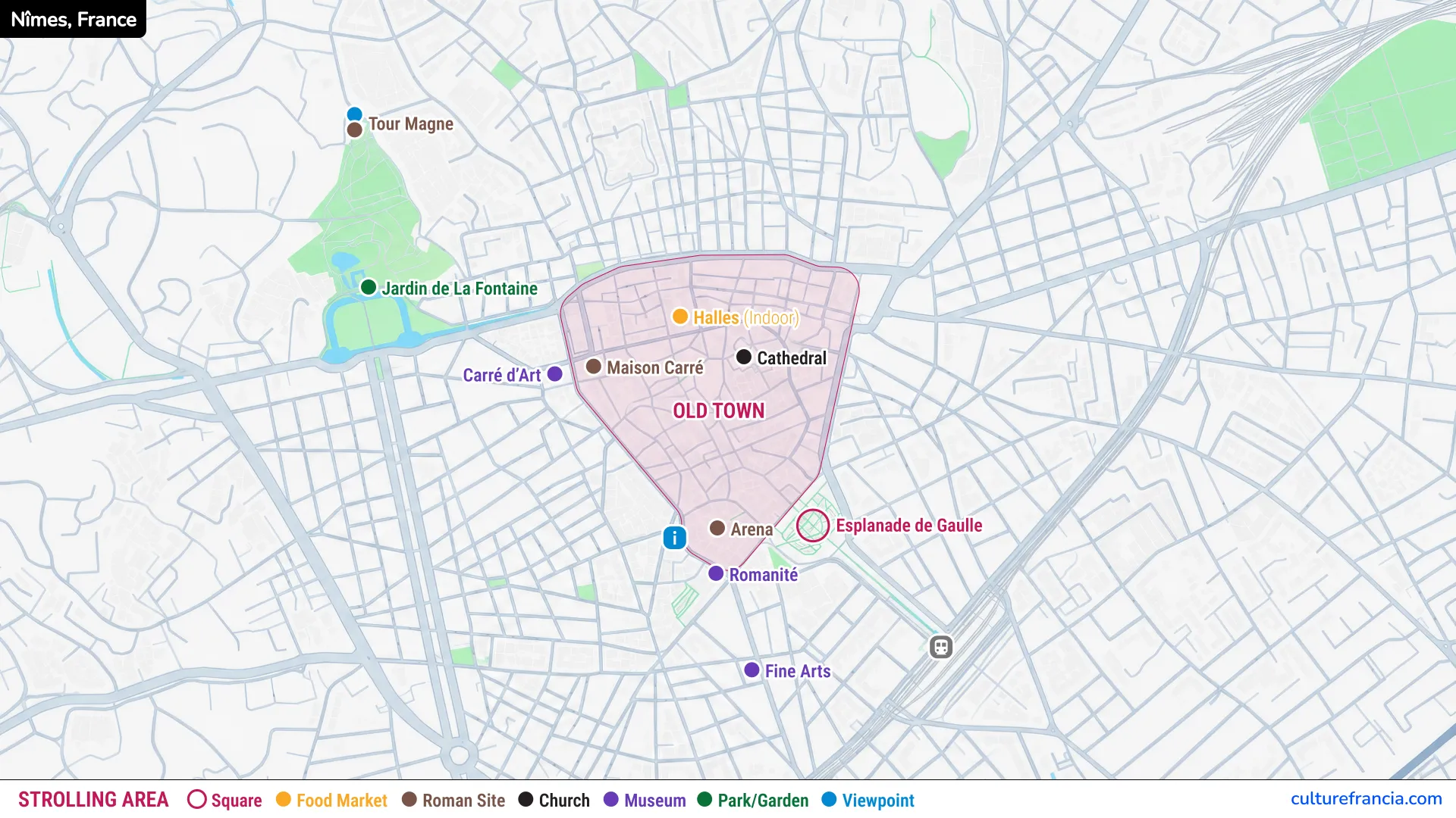
For quick planning, the image version is the simplest Nîmes city map to keep on your phone. It gives an immediate overview of the historic centre, the Arena of Nîmes, Maison Carrée, the Jardins de la Fontaine and the main Roman sites.
Save it before heading out, especially if you expect to spend the day walking. An image is also useful when mobile data is slow or when you simply want to check which attraction comes next without opening another app. The centre is compact, so a clear map is usually enough for most first-time visitors.
Nîmes Tourist Map PDF to Download or Print
Open the Nîmes Tourist Map PDF
The Nîmes tourist map PDF is the most practical choice for preparing a full sightseeing day. Download it before your trip, keep a copy offline, or print it if you prefer marking monuments and routes by hand.
A printable Nîmes map is particularly handy for families, travellers planning several museum visits, or anyone combining the city with nearby Roman heritage sites. We recommend using the PDF to identify your priority attractions first, then grouping them by area. This avoids zigzagging between the old town, the gardens and the eastern side of the historic centre.
Interactive Nîmes Tourist Map

Click on the icon  in the top-right corner to view the map in full screen.
Show/Hide layers as needed.
After clicking on the image,
click on the icon  in the top-left corner to display the map legend.
Show/Hide layers as needed.
The interactive version is best once you are already in the city. Use the interactive Nîmes tourist map for live orientation, zooming in on streets and checking exactly where each attraction sits.
It becomes especially useful around the narrow streets between the Arena and Maison Carrée, where wandering is part of the pleasure but losing twenty minutes is rather less charming. Tap the markers, compare nearby sights and adapt your route as the day unfolds. For travellers who like a flexible itinerary, this is the most convenient format.
Main Attractions on the Nîmes Tourist Map
Arena of Nîmes and Musée de la Romanité
The Arena is the obvious anchor point on any Nîmes attractions map. Built around the end of the 1st century AD, the vast Roman amphitheatre could hold roughly 24,000 spectators and remains one of the great surviving monuments of Roman Nemausus. If you have only a few hours in Nîmes, start here.
Directly opposite stands the Musée de la Romanité, all rippling contemporary glass against the Arena’s pale stone. Its archaeological collections make sense of what you see outside, from urban planning and religion to mosaics and everyday Roman life. The contrast also says something important about modern Nîmes: the city does not hide its ancient past behind glass, it builds around it.
Maison Carrée and Nîmes Historic Centre
From the Arena, the old town unfolds through small squares and pedestrian streets toward Maison Carrée. This is the heart of the Nîmes historic centre and the easiest section to explore without a strict route.
Maison Carrée was built in the 1st century AD in the Roman forum and dedicated to Gaius and Lucius Caesar, the designated heirs of Augustus. Its survival is extraordinary, but its setting is just as interesting: opposite, the Carré d’Art answers the temple’s classical columns with a contemporary architectural counterpart. The Maison Carrée was inscribed on the UNESCO World Heritage List in 2023.
Between the Arena and the temple, allow yourself a few detours through Place du Marché, Rue Fresque and Place de l’Horloge. This is where the tourist map becomes a guide rather than a set of instructions.
Jardins de la Fontaine, Temple of Diana and Tour Magne
West of Maison Carrée, the route follows the leafy Quais de la Fontaine to the Jardins de la Fontaine. Created in the 18th century around the ancient spring associated with Nemausus, the gardens are the prettiest transition from central Nîmes to its Roman past. Balustrades, pools, statues and terraces frame a site that had sacred importance long before the modern garden existed.
Near the spring stand the atmospheric remains known as the Temple of Diana. Then the route climbs through the gardens toward Tour Magne. The octagonal Roman tower rises above the city’s former defensive wall and rewards the climb with a broad panorama. Save Tour Magne for late afternoon if you can, when the light softens and the view over the rooftops is at its best.
Porte d’Auguste and Other Roman Sites
Porte d’Auguste lies on the eastern side of central Nîmes and is easy to add before or after exploring the old town. It is one of the clearest surviving clues to the scale of Roman Nemausus, whose fortified wall once extended for about seven kilometres.
Its four arched passages marked an important entrance on the ancient road linking Italy and Spain. A little farther from the core tourist circuit, the Castellum Aquae is another rewarding stop for Roman-history enthusiasts. This was where water arriving from the aqueduct was distributed through the city in a star-shaped system. Only a tiny number of comparable Roman structures survive.
Nîmes Old Town Map and Walking Route
A Walking Route Between the Main Sights
For a first visit, we recommend a simple westbound route that follows the city’s geography instead of constantly doubling back. The best Nîmes walking map is one that turns the main Roman monuments into a continuous walk.
- Start at the Arena and Musée de la Romanité, the easiest landmarks to identify and a natural introduction to Roman Nîmes.
- Continue through the historic centre to Maison Carrée, allowing time for the small squares and side streets rather than taking the shortest line.
- Walk along the Quais de la Fontaine to the Jardins de la Fontaine, where the dense city gives way to water and greenery.
- Climb past the Temple of Diana to Tour Magne, the logical high point and a satisfying end to the main route.
- Add Porte d’Auguste and the Castellum Aquae if time allows, either as extensions or as separate stops earlier in the day.
This sequence works particularly well because each stage changes character: amphitheatre, old streets, temple, formal gardens, then panoramic tower.
Walking Times Between Attractions
Nîmes is pleasantly compact. Most of the major sights are only about 5 to 15 minutes apart on foot, although the climb through the Jardins de la Fontaine to Tour Magne deserves a little more time.
Allow roughly 5 to 10 minutes from the Arena to Maison Carrée, around 10 minutes from Maison Carrée to the gardens, and another 10 to 15 minutes uphill to Tour Magne. These are sightseeing times rather than racing times. In Nîmes, a shaded square, an old façade or a tempting side street has a habit of stretching a five-minute walk into fifteen.
Getting Around Nîmes with the Map
From Nîmes Train Station to the Historic Centre
Nîmes Centre station is the useful arrival point for sightseeing, not to be confused with Nîmes Pont-du-Gard station outside the city. From the central station, a broad axis leads toward the Esplanade and the Arena. For most visitors arriving by train, walking is the easiest way to reach the main sights.
The Arena is close enough to make the transition from train to Roman monument almost absurdly simple. Once there, the old town, Maison Carrée and the western monuments can all be connected on foot. Travellers arriving at Nîmes Pont-du-Gard can use rail or connecting public transport to reach Nîmes Centre.
Public Transport and Parking
The centre is best explored on foot, but the local Tango network is useful for longer journeys. Use public transport for reaching the centre or crossing the wider city, then switch to walking for the historic core. The network includes Tram’bus and regular bus services, while several park-and-ride sites sit around the approaches to Nîmes.
Drivers will find regulated paid parking in central Nîmes as well as covered car parks near major sights. If you are visiting for several hours, a park-and-ride can be less stressful than circling the historic centre. The map is most useful before you park: choose the attraction where you want to begin, then select the nearest sensible parking option rather than driving from monument to monument.