MAP
Click on the icon ![]() in the top-right corner to view the map in full screen.
in the top-right corner to view the map in full screen.
The villages are in the 3rd layer.
Show or hide the other layers as needed.
OVERVIEW
Vibe
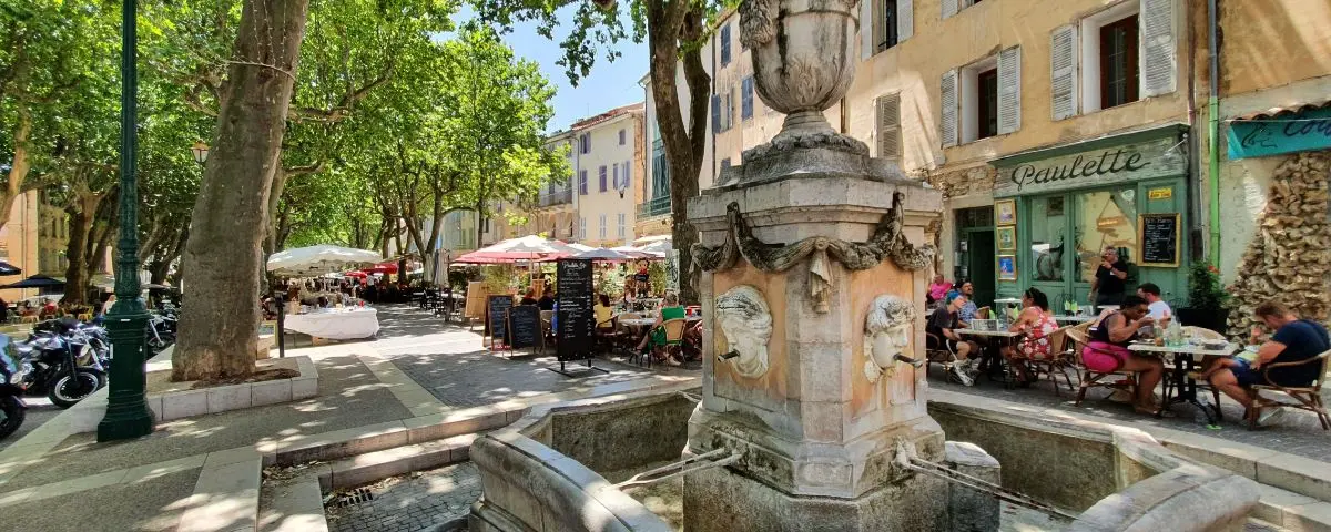
The French Riviera, with its hinterland, probably has the highest number of truly interesting villages of any region in France. To keep things simple, we’ve grouped them into 4 areas based on their location.
The vibe of a village can totally change depending on the season, the weather, the time of day, how crowded it is, or whether there’s the weekly food market (which can range from a few stalls to several dozen stalls) or a local event going on.
The best way to enjoy it? If possible, go at the right time, when it’s not too empty but not packed either. The descriptions you’re about to read are based on visits in ideal conditions, showing each place at its best.
For the more popular villages, often near the coast and easy to get to, it’s better to skip the peak hours in the middle of summer.
On the other hand, some of the more remote spots might feel sleepy off-season or when there’s nothing going on.
Sections
- EAST COAST (from Cannes to Italy)
8 Villages - WEST COAST (from St. Tropez to the Calanques)
7 Villages - EAST HINTERLAND (Southern Alps)
11 Villages - WEST HINTERLAND
11 Villages
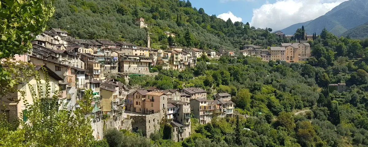
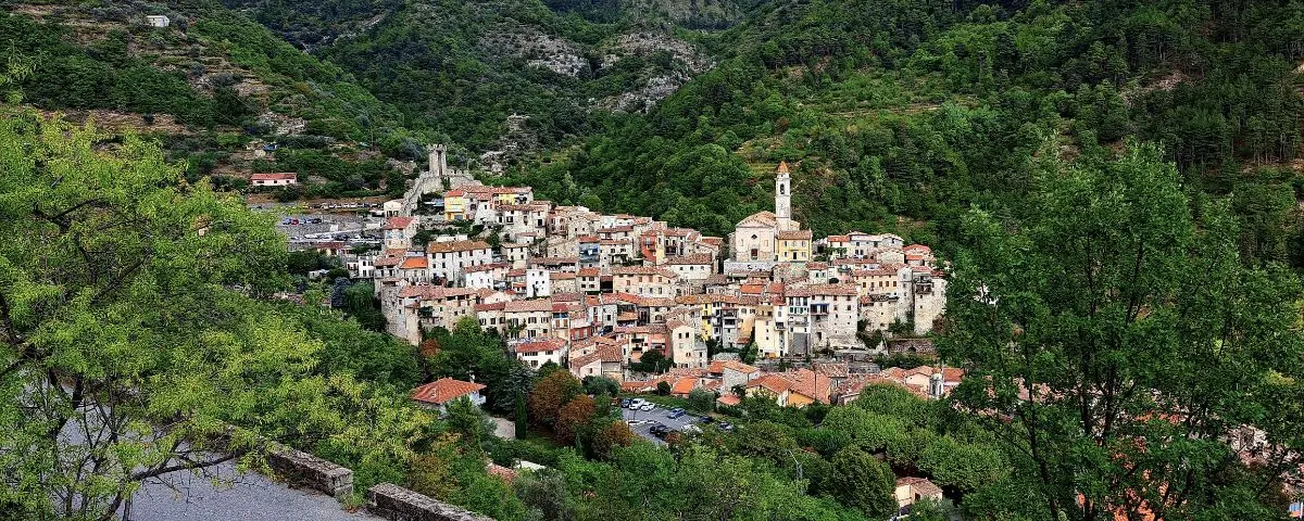
EAST COAST - Cannes to Italy
Between the hills and the Mediterranean, this stretch of coast is full of villages with rich heritage, charming architecture and a lively vibe. It’s where culture, elegance and sunshine meet.
| Name | Altitude m (ft) | To Coast¹ km (mi) | M | T | W | T | F | S | S |
|---|---|---|---|---|---|---|---|---|---|
| Èze | 400 (1310) | 0.6 (0.4) | ✓ | ✓ | |||||
| St. Paul-de-Vence | 200 (660) | 5.6 (3.5) | ✓ | ✓ | |||||
| Roquebrune | 220 (720) | 0.6 (0.4) | ✓ | ||||||
| La Turbie | 480 (1580) | 2 (1.2) | ✓ | ||||||
| Haut de Cagnes | 90 (300) | 1.8 (1.1) | |||||||
| Biot | 70 (230) | 2.6 (1.6) | ✓ | ✓ | |||||
| Valbonne | 200 (660) | 10 (6.2) | ✓ | ||||||
| Mougins | 250 (820) | 5.7 (3.5) | ✓ |
¹ Distance from the coast as the crow flies.
M T W T F S S = morning of the week when the village food market (and sometimes craft) takes place.
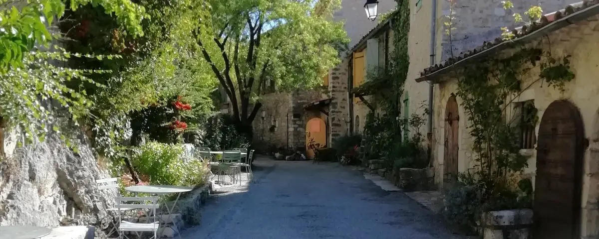
Èze
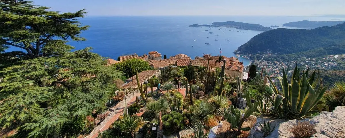
Altitude 400m (1310ft)
To Coast 0.6km (0.4mi)
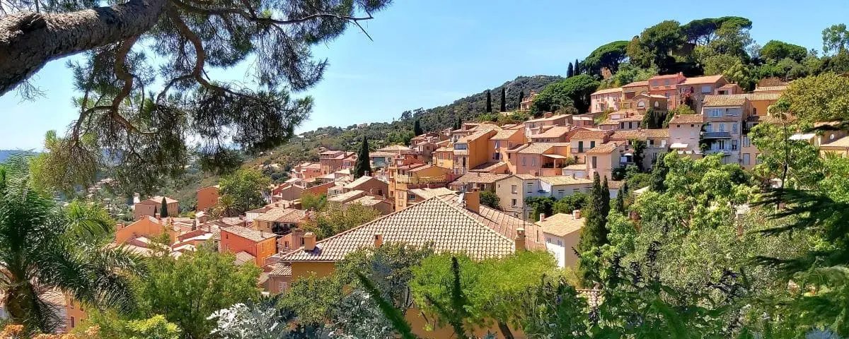
Hanging between the sky and the sea, Èze is one of the most iconic hilltop villages on the French Riviera. Clinging to the cliffside at over 400 meters above sea level, it gives you a spectacular view over the Mediterranean. It totally looks like a postcard, and yeah, it’s no hidden gem lots of people come here every year but even with the crowds, the village hasn’t lost an ounce of its charm.
As you climb up to the top, you follow these winding cobbled streets lined with beautifully restored medieval houses. You stroll around with your head in the clouds, checking out the arched passages, flower-covered façades, artisan workshops and little art galleries. Sure it’s a tourist hotspot, but the place still feels authentic.
And at the very top, the best part of the visit: the exotic garden. Set on the ruins of an old castle, this hanging haven is filled with stunning succulents, agaves and cacti from all over the world. But what’ll really blow your mind is the view a jaw-dropping panorama of the whole Riviera, from Saint-Jean-Cap-Ferrat all the way to Italy.
Èze is also perfect if you like to take your time. You’ll want to explore it early in the morning or late in the day, when there are less tourists and the streets get quiet again. With its rocky beauty, Mediterranean plants and that endless blue horizon, Èze captures that timeless Riviera vibe.
Food Market Thursday and Saturday mornings
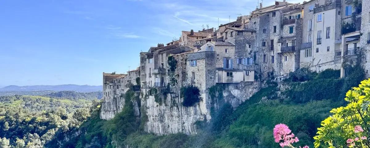
Saint-Paul-de-Vence
Altitude 200m (660ft)
To Coast 5.6km (3.5mi)
Perched on a hill, Saint-Paul-de-Vence is a true icon of the French Riviera. For a long time it was just a quiet fortified village, but in the 20th century, it took on a whole new artistic life. Back in the 1920s and 30s, when it was still just a peaceful hamlet, painters started showing up, drawn by the region’s ever-changing light. Their canvases and brushes settled there and pretty soon, writers and movie stars followed.
Today, even with all the tourists, the magic’s still very much alive. The cobbled lanes twist and turn between perfectly restored old stone buildings. You’ve got to take your time strolling down Rue Grande, lined with noble houses from the 16th and 17th centuries, now turned into art galleries, studios and little shops. The village’s soul is still deeply artistic with around fifty galleries and studios and of course the must-see Maeght Foundation, a major spot for modern European art, just on the edge of the village.
Walking the ramparts, gives you a peaceful stroll with wide views over the surrounding countryside. There’s also the Henri-Layet path along the western wall, where you can walk in calm.
A few more things: the Folon Chapel, decorated by the Belgian artist in a dreamy mix of stained glass, mosaics and sculptures; the collegiate church, packed with paintings from the 15th to the 18th century; and the cemetery, where Marc Chagall is buried.
Food Market Wednesday and Friday mornings
⚙️ Info (Tourist Office Website)
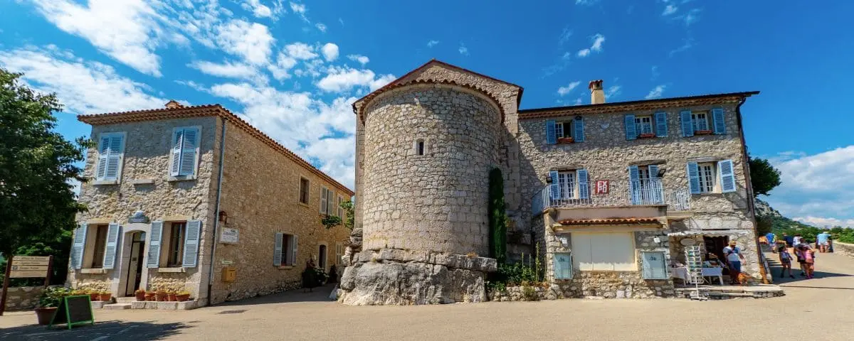
Roquebrune
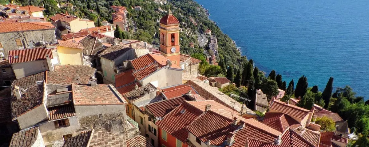
Altitude 220m (720ft)
To Coast 0.6km (0.4mi)
Overlooking the Mediterranean from its rocky spur, the old village of Roquebrune-Cap-Martin is a medieval gem tucked between Menton and Monaco. Sheltered from the coastal hustle, it spreads out in a maze of narrow, steep lanes lined with old houses connected by arches and covered passages. The vibe there is calm, almost like time’s standing still.
At the heart of the village stands a feudal castle from the 10th century the only one of its kind in France. This stark but striking fortress was gradually adapted for gunpowder use over the centuries. From the top of the walls, you get an amazing view over Cap Martin and the bay of Menton, with the Mediterranean stretching out in the background.
Just outside the village, stands the ancient olive tree of Roquebrune, this giant with multiple trunks is said to be over 2,000 years old and is listed among France’s remarkable trees. It’s a short walk from the main square and adds a poetic touch to your visit.
Roquebrune hasn’t lost its soul. If you go off-season or early in the morning, you’ll really feel the silence of the stone, the coolness of the shaded alleys and the raw beauty of a place whose quiet charm never fails to work its magic.
Food Market Thursday mornings
⚙️ Info (Tourist Office Website)
La Turbie
Altitude 480m (1580ft)
To Coast 2km (1.2mi)
Perched above Monaco, the village of La Turbie feels like a natural balcony over the Mediterranean. Its name’s forever tied to the stunning Trophy of Augustus, a majestic Roman monument built in the 1st century BC to celebrate Emperor Augustus’s victory over the Alpine tribes. You can spot it from far away and it’s a masterpiece of ancient art that shows just how important La Turbie was along the old Via Julia Augusta, parts of which are now followed by the modern Grande Corniche road.
The old village, still surrounded by traces of its medieval past, charms you with its narrow streets, vaulted alleys and secret passages. You enter through the west gate, the last bit left of the old wall, where a few lines from Dante’s Divine Comedy are carved in stone, talking about the village.
La Turbie is really a mix of epic history, jaw-dropping views and real-life authenticity a place floating somewhere between ancient Rome and today’s Mediterranean.
Food Market Thursday mornings
⚙️ Info (Tourist Office Website)
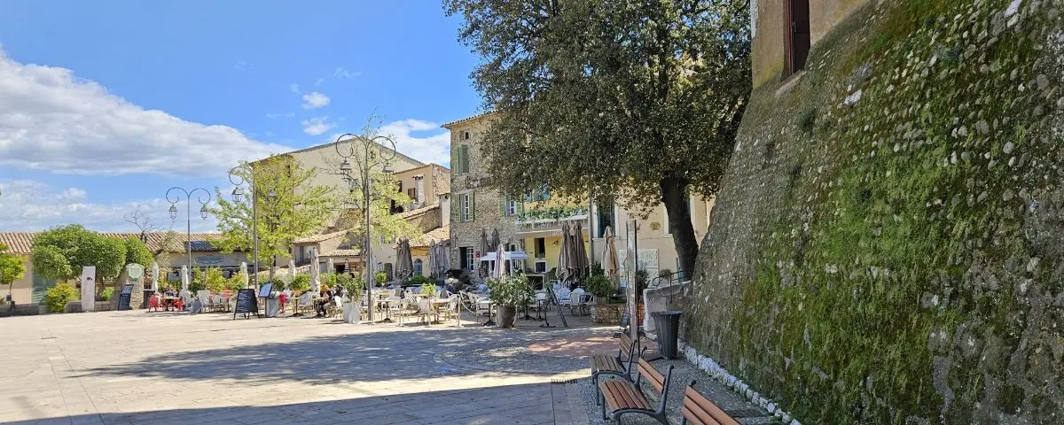
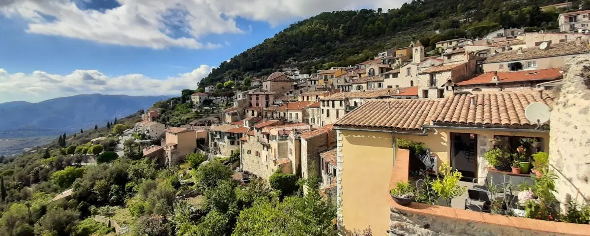
Haut de Cagnes
Altitude 90m (300ft)
To Coast 1.8km (1.1mi)
Perched between the sea and the hills, the medieval village of Haut-de-Cagnes is probably the most charming side of Cagnes-sur-Mer town. It’s a postcard-perfect maze of flower-filled lanes, stairways, vaulted passages and old houses from the 15th to 17th centuries, all bathed in that soft Provençal light.
Right in the middle of it all stands the Grimaldi Castle-Museum, built in the 14th centurt. Don’t let the plain exterior fool you inside, there’s an elegant courtyard with stacked galleries and a balustrade staircase. Up top, the panoramic terrace gives you an incredible view over the rooftops, the sea and the inland hills.
Close by, Saint-Pierre Church has two naves from different periods and some beautiful 17th-century paintings, while the little chapel of Notre-Dame-de-Protection has frescoes from the 16th century and a terrace that looks straight out over the Med.
Haut-de-Cagnes is also very much alive. You can settle down on the terrace of a small restaurant or guesthouse, bump into artists and travelers, and enjoy live jazz concerts in the summer right on the castle square.
With its medieval charm, vibrant culture and amazing views, Haut-de-Cagnes is a true slice of authenticity on the French Riviera.
Food Market No
The village of Haut-de-Cagnes doesn’t have a food market, but further down, in the town of Cagnes-sur-Mer, there are several.
⚙️ Info (Town Hall Website – Fr)
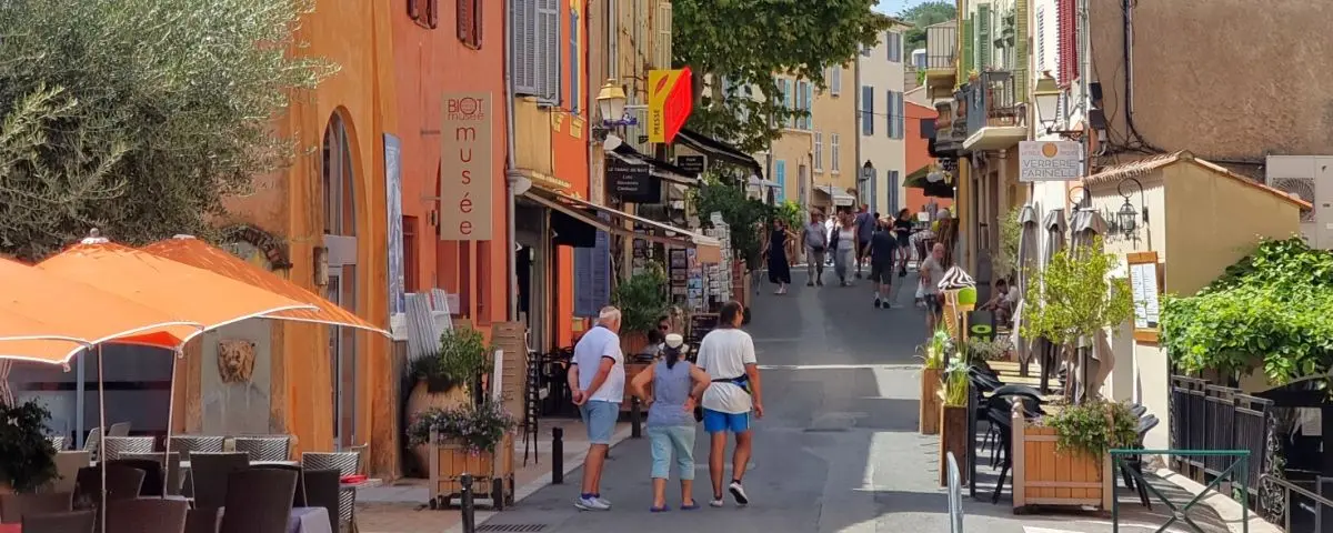
Biot
Altitude 70m (230ft)
To Coast 2.6km (1.6mi)
Just a few kilometers from the beaches of Antibes, perched on its little hill, Biot is a village of artisans that’s managed to keep its charm while always reinventing itself. Gently sloping cobbled streets, arched passages, old stone houses and a lovely central square, Place des Arcades, all set the scene for a place that makes you want to slow down and wander.
Since Roman times, Biot’s been known for its clay, once used to make jars for wine and olive oil. That faded a bit in the 19th century when metal containers took over, but in the 1950s, the village got a second wind thanks to the trend for decorative garden pottery. And nowadays, Biot is all about glassblowing.
There’s more to the culture here too. The Fernand Léger Museum, with its massive mosaics and modernist stained glass, has over 450 works by the master of colorful cubism. And the Museum of Biot History and Ceramics tells the story of the village through old objects, costumes and glazed pottery, all housed in a former chapel.
Walking through the village, you’ll spot remains of the 16th-century fortifications that hint at Biot’s strategic past. There’s the Tines and Migraniers gates, 14th-century arcades, and the Sainte-Marie-Madeleine church, which has two altarpieces, that give the place that medieval feel.
Biot’s also got plenty of life in it. You’ve got local farmers’ markets on Saturdays and a Provençal market Tuesday mornings, buzzing cafés and tons of little art galleries. And the village loves to celebrate, from the Mimosa Festival in February to the Harvest Festival in September.
Food Market
Tuesday mornings
⚙️ Info (Tourist Office Website)
Saturday mornings
⚙️ Info (Tourist Office Website)
Valbonne
Altitude 200m (660ft)
To Coast 10km (6.2mi)
Valbonne has this super unique layout, it was built in a perfect grid, like the old Roman military camps, which is pretty rare in Provence. It was founded in 1520 by the monks of Lérins, who were trying to bring life back to a region devastated by centuries of plague.
At its heart is Place des Arcades, a cozy, central square lined with houses that sit on low pillars, kind of like the bastides you see in southwest France. From there, straight little streets lead you through all sorts of lovely spots: Rue Grande, the old 19th-century town hall, an old fountain, and a historic stone trough. The village is lively, with artisan shops, cafés and terraces that make you want to sit and stay awhile.
Valbonne has a great vibe going on with its Friday morning market, all around the church square, where you can check out local food and crafts in a laid-back Provençal atmosphere.
Down by the river, the Romanesque chapel of Saint-Roch is worth a stop. It used to be part of an old abbey from the 13th-century.
Valbonne really has a mellow energy and is perfectly nestled between wooded hills and the buzz of the Riviera.
Food Market Friday mornings
⚙️ Info (Tourist Office Website)
Mougins
Altitude 250m (820ft)
To Coast 5.7km (3.5mi)
Behind Cannes, Mougins proudly looks out over the towns and hills all the way to the Prealps. The village spirals up like a snail shell around its old church tower, offering views of the Bay of Cannes, the Lérins Islands and the mountains around Grasse.
The heart of the old village is laid out like a seashell, curling around Place du Commandant-Lamy. The narrow streets have are lined with buzzing art galleries. The only remaining gate from the old fortifications is a reminder of the village’s medieval past.
Art is everywhere in Mougins. The Museum of Classical Art (MACM) holds a mix of Greco-Roman antiquities and pieces by Picasso, Matisse, Dali, Warhol and others. The Contemporary Photography Center puts on bold exhibitions year-round.
Mougins also shines when it comes to events. “Les Étoiles de Mougins” is a world-famous gastronomy festival where top chefs come together for demos and tastings. The Notre-Dame-de-Vie Festival hosts open-air opera concerts, while “Mougins Monumental” fills the village with sculpture installations each year.
In Mougins, elegance blends with that Provençal gentleness of life it’s all about art, stunning views and rich history.
Food Market Sunday mornings
⚙️ Info (Tourist Office Website)
WEST COAST - St. Tropez to Calanques
Here, the villages switch between little ports, lively alleys and sea views. You’ll feel the local history, the Provençal spirit and a real sense of warmth, all in a stunning natural setting.
| Name | Altitude m (ft) | To Coast¹ km (mi) | Label² | M | T | W | T | F | S | S |
|---|---|---|---|---|---|---|---|---|---|---|
| Bormes-les-Mimosas | 140 (460) | 2.6 (1.6) | ✔️ | ✓ | ||||||
| Le Castellet | 240 (790) | 7.1 (4.4) | ✔️ | ✓ | ||||||
| Gassin | 190 (620) | 3.9 (2.4) | ✔️ | |||||||
| Grimaud | 100 (330) | 4.2 (2.6) | ✓ | |||||||
| Port Grimaud | 0 | 0 | ✓ | ✓ | ||||||
| Ramatuelle | 130 (430) | 4 (2.5) | ✓ | ✓ | ||||||
| Garde-Freinet | 350 (1150) | 10 (6.2) | ✓ | ✓ |
¹ Distance from the coast as the crow flies.
² Plus Beaux Villages de France Label means “Most Beautiful Villages of France”.
Renowned label by an association for villages it considers France’s most beautiful.
M T W T F S S = morning of the week when the village food market (and sometimes craft) takes place.
Bormes-les-Mimosas
Altitude 140m (460ft)
To Coast 2.6km (1.6mi)
Label ✔️
Perched on the lower slopes of the Maures mountains, Bormes-les-Mimosas really stands out as one of the prettiest villages on the French Riviera. The old medieval part has been beautifully restored and you’ll love wandering through its steep little streets full of flowers, its vaulted passages, and all those sunlit stairways and tiny squares.
It’s actually even more charming outside the busy summer season, when you can really take in the village’s amazing plant life, around 700 species from all over the world that fill the place with incredible colours and scents.
Of course, it’s the mimosa that’s put Bormes on the map. It’s been officially linked to the village since 1920 and even gave it part of its name back in 1968. In January and February, the blooming mimosa transforms the whole area and draws in nature lovers, especially for the famous Corso fleuri, a spectacular flower parade that brings thousands of people together every year.
The village also has some lovely buildings worth checking out. The 18th-century Saint-Trophyme church is really elegant with its Romanesque style and old frescoes. Not far from there, the History and Art Museum, which is set in an old mansion, shows off local paintings, sculptures and art objects. And if you head uphill, you’ll get to the ruins of the medieval castle, where the view over Cap Bénat and the Îles d’Or is just stunning.
And Bormes doesn’t stop there, it celebrates its love of flowers all year round with events like Mimosalia at the end of January and the Medieval Festival at Pentecost. These traditions, along with the amazing scenery and laid-back vibe, really make the village a must-see on the Côte d’Azur.
Food Market Wednesday mornings
⚙️ Info (Tourist Office Website)
Le Castellet
Altitude 240m (790ft)
To Coast 7.1km (4.4mi)
Label ✔️
Le Castellet is a hilltop gem tucked away in the Var region, and as soon as you get there, you’ll be taken in by its perfectly preserved medieval vibe. Surrounded by old stone ramparts, the village center is packed with character, there’s a 12th-century church, a château, and a tangle of narrow cobbled streets winding between stone houses.
Sure, there are a few art galleries and plenty of touristy little shops nowadays, but the place still feels totally authentic. Fun fact: Marcel Pagnol shot the classic film The Baker’s Wife here which forever tied the village to the golden age of Provençal cinema.
From up there, you’ve got an incredible 360-degree view, to the north, the rugged peaks of the Sainte-Baume range, and to the south, the shimmering blues of the Mediterranean. That sea-and-mountain contrast makes every walk around here feel a bit magical. Just grab a seat at a local café terrace, sip a glass of Bandol wine, the vineyards are all around the village, and let yourself sink into that easy Provençal lifestyle.
Right nearby, you’ve also got the famous Paul-Ricard racetrack, which draws motorsport fans from all over every year. It’s perched on the Castellet plateau and adds another layer to the village’s reputation.
Basically, it’s got everything you imagine when you think of a picture-perfect Provençal village.
Food Market Saturday mornings
⚙️ Info (Tourist Office Website)
Gassin
Altitude 190m (260ft)
To Coast 3.9km (2.4mi)
Label ✔️
Gassin is a hilltop village in the Var region, perched high above the Saint-Tropez peninsula. You get there by winding your way up a twisty road, and once you’re at the top, the view is just stunning, you can see the whole Gulf of Saint-Tropez dotted with boats, like a living painting straight out of a Paul Signac piece. He actually stayed there once, which makes the scene even more poetic.
Part of Gassin’s charm comes from its old historical features. You’ll find yourself strolling past ancient ramparts, stone-paved alleys, and cute little archways. One quirky highlight is the narrowest street in the world.
What really makes Gassin special is how deeply rooted it is in its winegrowing tradition. The village has kept its farming alive, especially with vineyards, which not only keeps the landscape looking beautiful but also supports a sustainable local economy.
If you’re into plants, you’ll love the two gardens. The Marie-Thérèse L’Hardy Garden has nearly 600 types of Mediterranean plants and gives you an amazing view over the valley. And then there’s the Gassin Garden, outside the village, which covers two hectares and was designed with biodiversity in mind, don’t miss the stunning rose garden with 300 old varieties.
With its peaceful Provençal vibe, beautiful landscapes and rich heritage, Gassin really feels like a magical little escape floating between sky and sea.
Food Market No
Grimaud
Altitude 100m (330ft)
To Coast 4.2km (2.6mi)
Grimaud is one of those iconic hilltop villages in the Var. Nestled between the Maures mountains and the Gulf of Saint-Tropez, it still shows off its medieval roots, especially with the old castle towers that rise above the landscape. What used to be a defensive stronghold is now a real gem for visitors, mixing Provençal charm with beautifully restored buildings and loads of blooming flowers.
Wandering through the village is a treat, a mix of shade and sun, cobbled streets, stone stairways, quiet little squares, and façades draped in wisteria and bougainvillea. Naturally, the path takes you up to the ruins of the medieval castle, and the view from up there totally makes the climb worth it.
Among the historic highlights, you’ve got the Saint-Michel church with its simple, Romanesque design. You’ll also pass by a lovely old house with arcades from the 15th and 16th centuries, a reminder of the village’s former wealth.
In summer, Grimaud hosts Les Grimaldines, a world music festival held right at the castle. There are free street performances before the main shows, which really bring the village to life.
With all its history, natural beauty and living traditions, Grimaud isn’t just a pretty place to look at, it’s a village full of soul, and once you’ve been, it’s not one you’ll forget.
Food Market Thursday mornings
⚙️ Info (Tourist Office Website)
Port Grimaud
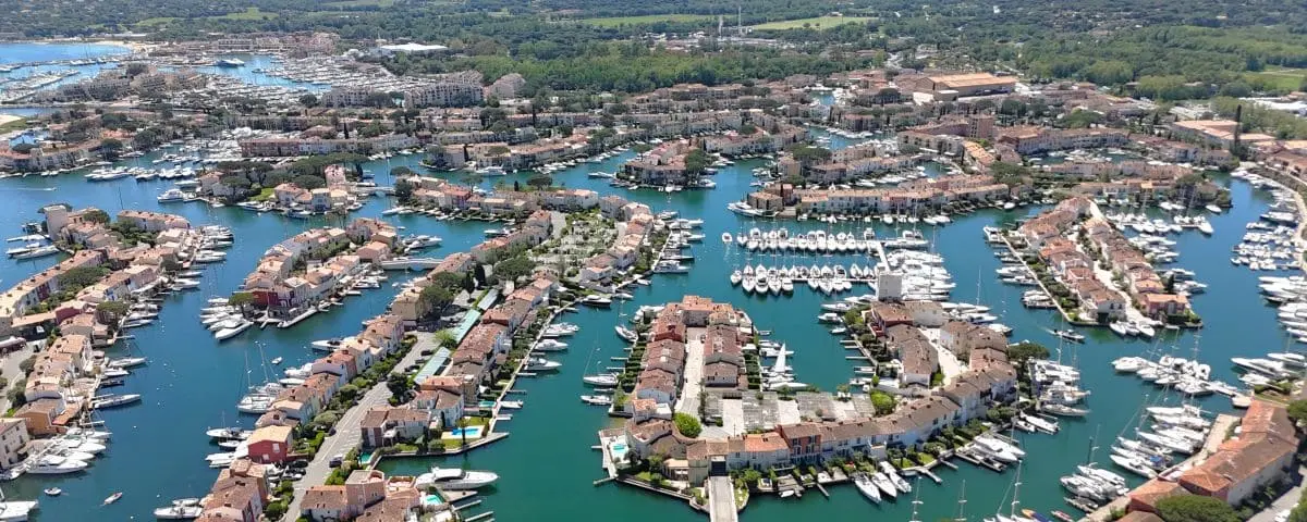
Altitude 0
To Coast 0
Tucked at the end of the Gulf of Saint-Tropez, you’ll find Port Grimaud, a bold creation born in 1966 from the mind of an architect from Alsace. His vision? Turn a swampy stretch of land into a colorful Mediterranean village built around canals, kind of like a Provençal Venice.
With about 2,500 homes and 7 km of canals lined by 12 km of quays, Port Grimaud is like something out of a dream. Boats are docked right at people’s doorsteps. Every detail was carefully planned to blend beauty, practicality and that sweet Provençal lifestyle. The buildings follow traditional architecture, with soft pastel façades that reflect beautifully in the water.
You should definitely check out the Saint-François des Sables church, it looks a bit like a little fortress. If you climb up to its terrace, you’ll get a breathtaking view over the whole village. Inside, there are modern stained-glass windows by Victor Vasarely, adding a splash of bold color and creativity to the space.
The whole village is pedestrian-only, which makes it perfect for walking around or, better yet, cruising through the canals. You can hop on a little water taxi, for a guided tour.
Port Grimaud has its charm any time of day, but in the late afternoon, when the golden light hits those pastel walls, it feels almost magical. It’s a one-of-a-kind place, part lived-in village, part marina, part picture-perfect postcard, where modern design and Provençal inspiration come together beautifully.
Food Market Thursday and Sunday mornings
⚙️ Info (Tourist Office Website)
Ramatuelle
Altitude 130m (430ft)
To Coast 4km (2.5mi)
Clinging to the hillside and surrounded by vineyards, Ramatuelle is a medieval village in the Var that’s kept all its old-school charm. The tall houses line up like a natural fortress, almost as if they’re still standing guard against past invasions. The village has been carefully restored and, while it gets pretty touristy in peak season, it still holds onto a strong local spirit and stays wonderfully peaceful the rest of the year.
Just wandering through the narrow streets is a treat, the walls are covered in bougainvillea and evening primrose, giving the place a timeless Provençal feel. The heart of the village is the Place de l’Ormeau, and not far off you’ll find the Notre-Dame church, leaning against the old ramparts. It’s full of character, with a serpentine stone portal, a couple of 17th-century altarpieces and a bell tower that used to serve as a watchtower.
Ramatuelle also comes alive with culture. Every summer, it hosts the famous Festival de Ramatuelle, with music, theater and variety shows. Then around mid-August, there’s a jazz festival that brings a relaxed, music-loving vibe to the village.
With its mix of heritage, culture and nearby beaches, Ramatuelle really captures a certain kind of Côte d’Azur, one that’s elegant, preserved, and deeply rooted in its land.
Food Market Thursday and Sunday mornings
⚙️ Info (Tourist Office Website)
Garde-Freinet
Altitude 350m (1150ft)
To Coast 10km (6.2mi)
Just 10 km north of Grimaud, right in the heart of the Maures mountains, La Garde-Freinet is a village that’s stayed fiercely authentic. Surrounded by vast chestnut forests, it sits on a mountain pass like a lookout point between the Gulf of Saint-Tropez and the Maures plain.
The village stayed isolated for a long time, almost self-sufficient, relying on local resources, chestnut farming and cork harvesting, all the way up to the 19th century. You can still get a feel for that past at the Conservatoire du patrimoine du Freinet, set inside the old Saint-Jean chapel. The museum has exhibitions on farming traditions, tools, local plants, and even archaeological finds from the ancient fortified village.
La Garde-Freinet has managed to avoid the noisy tourist crowds and holds on to a rare kind of peace. The village center, with its little squares, fountains, is perfect for taking a slow stroll.
Just a kilometer from the center, you can hike up to Fort Freinet, a medieval village carved into the rock at 450 meters up. The site dates back to the 12th century and has the remains of houses, a chapel and defensive ditches, plus a killer view over the whole region.
The cultural calendar’s lively too: the big Chestnut Festival on the last two Sundays of October, and a Santons Fair (with those classic Provençal figurines) at the end of the year, all keeping that Provençal spirit alive all year long.
With its deep roots, untouched scenery and proud independence, La Garde-Freinet is one of the most genuine and hidden villages in the inland Côte d’Azur, and yet it’s still not far from the coast.
Food Market Wednesday and Sunday mornings
⚙️ Info (Tourist Office Website)
EAST HINTERLAND - Southern Alps
This mountain area is home to villages with deep roots and loads of character. Picture valleys, stone houses, strong traditions and a true mountain personality.
| Name | Altitude m (ft) | To Coast¹ km (mi) | Label² | M | T | W | T | F | S | S |
|---|---|---|---|---|---|---|---|---|---|---|
| St. Agnès | 660 (2160) | 4.3 (2.7) | ✔️ | |||||||
| Saorge | 530 (1740) | 22 (14) | ✔️ | ✓ | ||||||
| Coaraze | 640 (2100) | 17 (11) | ✔️ | |||||||
| Tende | 820 (2690) | 34 (21) | ✓ | |||||||
| La Brigue | 780 (2560) | 30 (19) | ✓ | |||||||
| Sospel | 350 (1150) | 12 (7.5) | ✓ | ✓ | ||||||
| Peille | 640 (2100) | 6.4 (4) | ||||||||
| Peillon | 340 (1120) | 5.4 (3.4) | ||||||||
| Castellar | 370 (1210) | 2.7 (1.7) | ✓ | |||||||
| Gorbio | 350 (1150) | 3.2 (2) | ✓ | |||||||
| Lucéram | 670 (2200) | 17 (11) |
¹ Distance from the coast as the crow flies.
² Plus Beaux Villages de France Label means “Most Beautiful Villages of France”.
Renowned label by an association for villages it considers France’s most beautiful.
M T W T F S S = morning of the week when the village food market (and sometimes craft) takes place.
St. Agnès
Altitude 660m (2160ft)
To Coast 22km (14mi)
Label ✔️
Perched high above Menton on a cliffside, Sainte-Agnès is officially the highest coastal village in Europe, and the view over the Mediterranean is absolutely breathtaking. It’s a rare spot, home to a perfectly preserved old village with a maze of tiny alleys, medieval archways, vaulted passages, and a cobbled main street that leads you to an incredible lookout point.
What makes Sainte-Agnès so special is its mix of history and military heritage. The Fort Maginot de Sainte-Agnès, dug right into the mountain, is basically an underground city covering 2,000 square meters. It played a defensive role during World War II and now you can visit it, with everything from bunkers and kitchens to big machinery and a modern setup that brings its story to life.
Another gem is the old medieval castle site, which you reach via a steep little trail. Up among the ruins, there’s a terraced medieval garden planted with species from the era. It’s a simple, peaceful place that feels both poetic and timeless.
Sainte-Agnès isn’t just about dramatic views, it’s a real haven, where every stone has a story, every viewpoint invites you to pause, and the whole village feels like it’s suspended between sky, sea and memory.
Food Market No
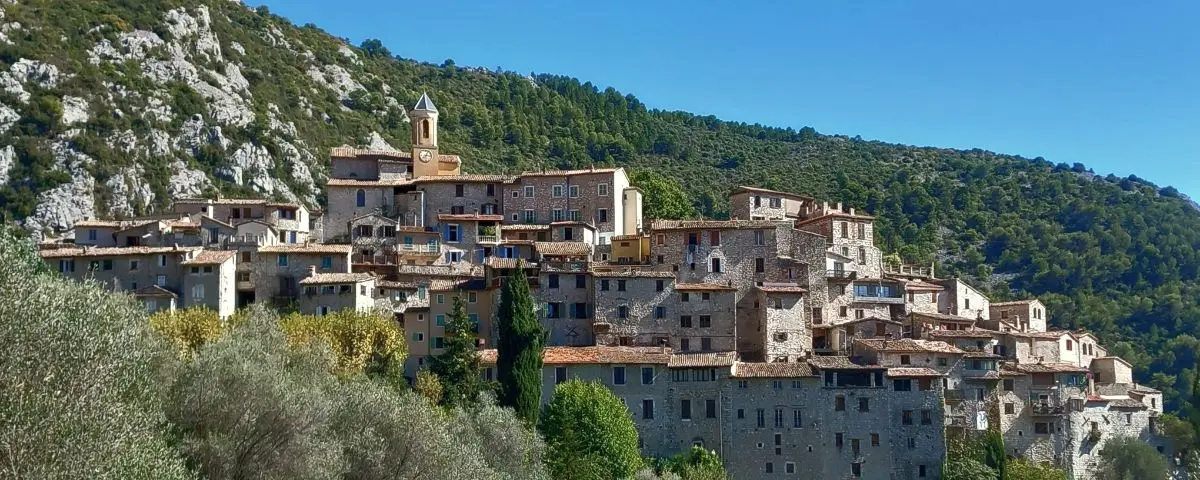
Saorge
Altitude 530m (1740ft)
To Coast 22km (14mi)
Label ✔️
Perched on the mountainside in the upper Roya valley, Saorge rises like an eagle’s nest, both majestic and dizzying. Its tall houses from the 15th to 17th centuries, painted in shades of violet slate, ochre and faded blue, are stacked on steep rock faces, almost defying gravity. With their balconies hanging over the void, they form a natural wall overlooking the valley, all turned toward the sun.
The village also has some amazing religious heritage, especially the Notre-Dame-des-Miracles Monastery, founded in the 17th century. It sits at the top of the village and is known for its beautiful Franciscan frescoes.
Nature plays a big part in Saorge’s charm too. Just at the entrance of the village. Down the road, the rock pools of the Bendola, known locally as the “bath of the Semite”, offer a refreshing and scenic swim spot.
And then there’s the village life, welcoming and laid-back, with guesthouses, cozy little eateries and cultural events throughout the year.
Saorge is one of those rare places that feels suspended between sky and mountains, history and silence, a spot that grabs you with its raw beauty and peaceful soul.
Food Market Saturday mornings
⚙️ Info (Tourist Office Website)
Coaraze
Altitude 640m (2100ft)
To Coast 17km (11mi)
Label ✔️
Coaraze is a medieval gem set in a bright, olive- and cypress-covered landscape. The village wins you over with its stepped alleyways, vaulted passages, flower-filled little squares with old fountains, and a timeless atmosphere. From the top of the village, you get an amazing view over the valley.
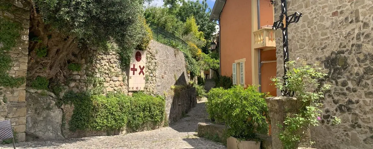
Since the 1960s, Coaraze has had a real love affair with sundials, many of them made by artists. These colorful pieces are scattered around the village, on the town hall and along the wall by the church square, turning light and time into something almost poetic.
There’s also a rich religious heritage. The Saint-Vincent church, originally Gothic from the 14th century but rebuilt a few times, now shines in full-on baroque style. Just nearby, the Notre-Dame-des-Sept-Douleurs chapel, known as the “Blue Chapel”, is famous for its 1960s frescoes and its stunning view over the village and the valley.
And Coaraze isn’t just about quiet charm, it knows how to party too. In July, it hosts the Championship of pilou (a traditional Niçois game), in August the Rencontres chorales de l’Olivier, and the Coartjazz festival with masterclasses, jam sessions and concerts. So even if the village seems still, you’ll find time dancing to its own rhythm here.
Food Market No
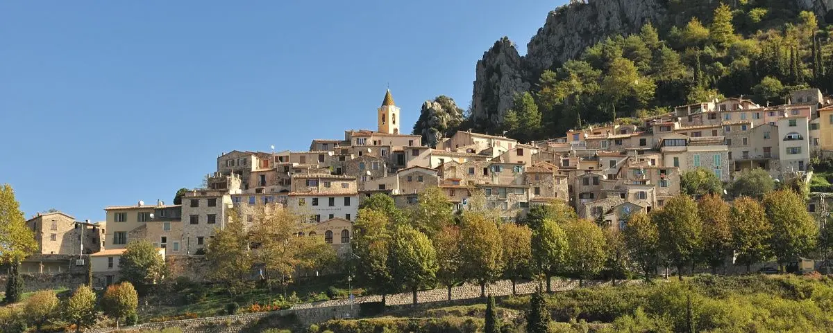
Tende

Altitude 820m (2690ft)
To Coast 34km (21mi)
Built like an amphitheater above the Roya River, Tende is a small alpine town full of character, where tall slate-roofed houses seem to hang between sky and earth. It’s surprisingly lively and full of shops, despite being relatively remote.
Thanks to its strategic location, Tende once had major military importance. Back in the Middle Ages, it controlled access to the Piedmont region, making it a key spot in the power struggles between France and the House of Savoy.
The old town is a true showcase of mountain architecture, vaulted passages, stone stairways, arcaded squares, fountains, and doorways framed in green schist with old coats of arms.
Tende is also home to the incredible Musée des Merveilles, dedicated to the famous rock carvings of Mont Bégo in the Mercantour National Park. The museum displays over 36,000 petroglyphs and mixes archaeology, ethnography and geology with lifelike models and reconstructions.
And the village knows how to keep its traditions alive, there’s the Fête des Muletiers (mule drivers’ festival) in July, a big farmers’ celebration in August, and the Fête du Vieux Tende with parades, dancing, giant polenta and traditional music all summer long.
Tende feels like a gateway to another world, one where wild nature, ancient heritage and alpine traditions come together to form the beating heart of the upper Roya valley.
Food Market Wednesday mornings
⚙️ Info (Tourist Office Website)
La Brigue
Altitude 780m (2560ft)
To Coast 30km (19mi)
La Brigue is a village with a strong medieval vibe, tucked away in the upper Roya valley. It’s overlooked by the ruins of the Lascaris castle, and this place really has character. As you wander through its maze of cobbled streets, you’ll come across arcaded houses, and green schist lintels carved with coats of arms, some going all the way back to the 15th century.
You’ll spot several religious buildings along the way, like the Saint-Sauveur church and the Saint-Claude chapel with its colorful glazed-tile bell tower. But the real gem is the Saint-Martin collegiate church, with its tall Lombard-style bell tower and an incredibly ornate baroque interior.
What makes La Brigue even more special is the Maison du patrimoine brigasque, a kind of living museum that dives into local arts and traditions. Inside, you’ll find old-timey scenes like a working beehive, a vintage classroom, a cobbled street, and a section all about the region’s famous organs, crafted by old Italian organ makers.
Not far from there, in the next valley over, there’s another hidden treasure, the chapel of Notre-Dame-des-Fontaines. People call it the “Sistine Chapel of the Alps.” You can get there by road or hike up a trail. Inside, the frescoes are stunningly lifelike, bringing Gospel scenes to life.
And La Brigue isn’t just about history. It’s full of life, with a local farmers’ market every Sunday and festivals like the big medieval fair in July.
Between its spiritual landmarks, rich past, and deep-rooted traditions, La Brigue is like a little Alpine jewel. It’s the kind of place you take your time with, like flipping through the pages of an old, beautiful book.
Food Market Sunday mornings
⚙️ Info (Tourist Office Website)
Sospel
Altitude 350m (1150ft)
To Coast 12km (7.5mi)
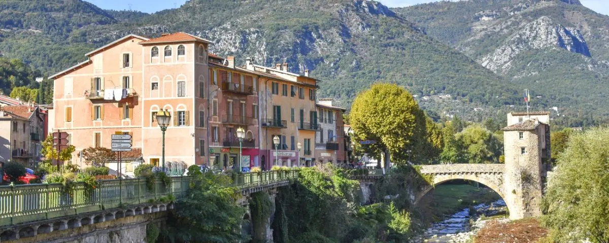
Tucked away in the heart of the Bévéra valley, Sospel is a little town that blends medieval charm, a rich strategic past, and stunning nature. Back in the day, it was the second most important city in the County of Nice and played a key role on the Salt Road, which brought it wealth. Today, both sides of the river still have that old-world feel, perfect for history buffs, heritage lovers, and hikers.
One of the town’s most iconic spots is the old bridge with its fortified tower. It stretches across the Bévéra and links two banks lined with tall, colorful houses.
On the right bank, you’ll find Cathedral Square, a beautiful mix of buildings like the Ricci Palace, arcaded houses, a cobblestone forecourt, and Saint-Michel Cathedral, which was rebuilt in the 17th century and still has its Romanesque bell tower. Right next to it, the chapels of the Red and Grey Penitents now host a cinema and temporary exhibits.
In summer, the BaroQuiales festival brings baroque music to life inside the stunning cathedral, and at the end of August, the film festival takes over the Red Penitents’ chapel.
With its mix of history, culture, and trails, Sospel is a perfect gateway to the Nice backcountry and the Mercantour National Park, a village that’s as warm and welcoming as it is fascinating.
Food Market
Thursday mornings
⚙️ Info (Tourist Office Website)
Sunday mornings
⚙️ Info (Tourist Office Website)
Peille
Altitude 640m (1120ft)
To Coast 6.4km (4mi)
Tucked away in a wild and rugged setting, Peille is a jaw-dropping village wedged between a steep rock face and the ruins of a medieval castle. This stony landscape is softened by olive trees, fig trees, and cypresses clinging to the slopes.
Right in the heart of the old village, you’ll discover an amazing medieval ensemble, Romanesque houses with touches of Gothic, carved lintels, cascading little alleyways, and vaulted passageways. On André-Laugier square, there’s a 15th-century fountain, and just above it stands a house that used to be the seat of the consulate of the Counts of Provence.
From there, if you climb up the Lascaris street to the war memorial, you’ll be rewarded with a stunning view over the olive groves, terraced gardens, and even all the way out to the sea, with Nice and the Estérel in the background.
The village’s gem is the Sainte-Marie church, which still has a 12th-century Romanesque nave that’s architecturally fascinating.
And if you’re there in August or September, you can join in the local celebrations, the Lavender and Wheat Festival on the first Sunday of August, and the charming Festin des Baguettes in September, a sweet and poetic tradition that really captures the spirit of this fiercely proud little village.
Food Market No
Peillon
Altitude 340m (1120ft)
To Coast 5.4km (3.4mi)
Perched on the side of a cliff, Peillon is reached by a narrow, winding road that twists through olive trees, broom, and pines. As soon as you arrive, it hits you, the place feels frozen in time. The village looks like it’s curled up between its tall, fortress-like houses, giving off this striking, timeless vibe. With no school or shops, Peillon turns into a haven of silence and reflection in the off-season, a perfect setting for a slow, poetic wander through its steep alleys, all the way up to the little hilltop square and its peaceful church.
That church, Saint-Sauveur, stands on the old castle’s spot and looks out over the village from a charming plaza. It’s got a 16th-century chapel, a late 18th-century classical facade, and just above it, a viewpoint with an incredible panorama of the valley.
And you can’t miss the chapel of the White Penitents, tucked against the cliff below the village. Built in the 12th century, its altar is carved right into the rock. The vaulted ceiling holds some stunning frescoes. Even if it’s closed, you can still see the artwork through the entrance gate.
Peillon, with its wild beauty, deep quiet, and artistic treasures, feels like it belongs to another era, a stone refuge where you can really soak in the stillness and the light.
Food Market No
Castellar
Altitude 370m (1210ft)
To Coast 2.7km (1.7mi)
Up north of Menton, Castellar clings to the first foothills of the Alps with a calm and picturesque vibe. This lovely hilltop village is a real maze of narrow parallel lanes, vaulted passageways, and staircases winding between old stone houses. It’s got a strong village spirit, well away from the buzz of the coast.
The historic center is crossed by rue de la République, which actually runs right under the old Lascaris palace, that was the home of a powerful local noble family. The building looks both stern and majestic and reminds you of the village’s rich history. A bit further down, the chapel by the cemetery adds a poetic, peaceful touch to the whole setting.
With its heritage, steep hiking paths, and down-to-earth welcome, Castellar is the kind of place that sticks with you, where the mountains meet the sea in rare and peaceful harmony.
Food Market Sunday mornings
⚙️ Info (Tourist Office Website)
Gorbio
Altitude 350m (1150ft)
To Coast 3.2km (2mi)
Gorbio is a hilltop village set in a wild, unspoiled landscape. It’s got this raw, authentic charm, with cobbled lanes worn smooth by time, stone archways, and an atmosphere that feels caught somewhere between the sea and the mountains.
One of its most surprising traditions is the famous “Procession of the Snails,” held every June for Corpus Christi. During the event, the streets and windowsills are lit up with thousands of snail shells turned into little candles, a magical and moving scene that’s totally unique in the region.
Gorbio also holds a few local treasures, like the big old elm tree standing proudly in the center of the village and the ancient fountain that greets you at the entrance. These touches quietly tell the story of a place that’s simple but full of life.
All in all, Gorbio might be low-key, but it’s got a powerful sense of authenticity, a peaceful little escape on the edge of the Riviera, where tradition and natural beauty go hand in hand.
Food Market Saturday mornings
⚙️ Info (Tourist Office Website)
Lucéram
Altitude 670m (2200ft)
To Coast 17km (11mi)
Lucéram is a classic village of the Nice backcountry, known for its tall, tightly packed houses clinging to the rocky hillsides. This medieval spot, with its fortress-like feel, is full of narrow, winding alleys, vaulted passageways, staircases, old bread ovens, and ancient fountains.
What really puts Lucéram on the map is its famous Nativity trail, held every year from early December to early January. Around 500 handmade cribs, crafted from simple materials, are displayed all over the village, in streets, windows, little niches, and hidden corners. Even outside the holiday season, about fifty of them stay on display thanks to a marked route.
The village’s religious heritage is also worth checking out. Lucéram is home to several chapels, especially the Sainte-Marguerite church, which was redone in the 18th century with a touch of Italian rococo.
Surrounded by rocky scenery that hints at the twists and turns of the Turini Pass and the first slopes of the Mercantour National Park, Lucéram is both a gateway to the mountains and a quiet place rich in history and soul.
Food Market No
WEST HINTERLAND
Built on soft hills or steeper slopes, this region brings together villages where heritage, nature and the good life blend perfectly. It’s just right if you’re after a real, vibrant taste of Provence.
| Name | Altitude m (ft) | To Coast¹ km (mi) | Label² | M | T | W | T | F | S | S |
|---|---|---|---|---|---|---|---|---|---|---|
| Cotignac | 240 (790) | 45 (28) | ✔️ | ✓ | ||||||
| Tourtour | 640 (2100) | 40 (25) | ✔️ | ✓ | ✓ | |||||
| Seillans | 400 (1310) | 27 (17) | ✔️ | |||||||
| Bargème | 1070 (3510) | 37 (23) | ✔️ | |||||||
| Gourdon | 730 (2400) | 16 (10) | ✔️ | |||||||
| Tourrettes-sur-Loup | 380 (1250) | 11 (6.8) | ✓ | ✓ | ||||||
| Cabris | 550 (1800) | 15 (9.3) | ✓ | |||||||
| Mons | 810 (2660) | 26 (16) | ✓ | |||||||
| Châteaudouble | 500 (1640) | 31 (19) | ✓ | |||||||
| Fayence + Tourettes | 350 (1150) | 23 (14) | ✓ | ✓ | ✓ | |||||
| Villecroze | 330 (1080) | 42 (26) | ✓ |
¹ Distance from the coast as the crow flies.
² Plus Beaux Villages de France Label means “Most Beautiful Villages of France”.
Renowned label by an association for villages it considers France’s most beautiful.
M T W T F S S = morning of the week when the village food market (and sometimes craft) takes place.
Cotignac
Altitude 240m (790ft)
To Coast 45km (28mi)
Label ✔️
Tucked at the bottom of a valley beneath a dramatic tuff cliff, the town center of Cotignac feels like a dream of a southern village. Surrounded by vineyards, pines, and olive trees, it charms you with its easygoing vibe, shady squares, old fountains, and warm-colored facades. The village stretches along the base of a huge rock dotted with troglodyte caves.
It stayed off the radar for a long time, the road didn’t even reach it until the 19th century, and that helped Cotignac hold onto a rare sense of authenticity. Its name comes from the quince fruit.
The heart of the village beats around cours Gambetta, lined with centuries-old plane trees and centered around a fountain. On Tuesdays, when the market is on, it’s full of life. It’s also the cultural hotspot of the village. The old chapel of the White Penitents has been turned into La Falaise art center, hosting modern art shows every summer.
Over on Place de la Mairie square, topped by a lovely little bell tower, you’ll see arcaded houses, old facades, and artists’ studios. And if you head down the Grande-Rue, keep an eye out for the 17th-century caryatids, stone statues that once showed off the social status of the families who lived there.
Cotignac is truly one of a kind, a place where nature, history, and modern life all come together in harmony.
Food Market Tuesday mornings
⚙️ Info (Tourist Office Website)
Tourtour
Altitude 640 (2100ft)
To Coast 40km (25mi)
Label ✔️
Tourtour sits high above a landscape of wooded hills scented with thyme and rosemary. The place draws in both visitors and artists, with several galleries dotted around the village.
The approach alone is stunning, you arrive via a panoramic road that already gives you a taste of what’s to come. Once you’re in the village, it’s all about wandering through Renaissance-style houses with carved facades, cobbled lanes, shady little squares, and softly murmuring fountains.
The old 12th-century castle reminds you of its feudal roots, while the 11th-century Saint-Denis chapel, outside the village, offers an incredible view all the way to the Maures mountains, Sainte-Victoire, and Sainte-Baume.
With its heritage, artistic vibe, and jaw-dropping views, Tourtour strikes a rare balance, perched in altitude, full of inspiration, and wrapped in that soft Provençal charm.
Food Market Wednesday and Saturday mornings
⚙️ Info (Tourist Office Website)
Seillans
Altitude 400m (1310ft)
To Coast 27km (17mi)
Label ✔️
Perched up in the hills, Seillans looks like something straight off a postcard, a real maze of narrow winding alleys with vaulted passages, old washhouses, trickling fountains, shady little squares, and bits of ancient ramparts here and there. You enter the village through a 12th-century gate that sets the tone, and every corner feels like it’s telling a quiet story of Provence.
Artists have always been drawn to Seillans. The surrealist painter Max Ernst and his partner Dorothea Tanning spent their final years here, leaving behind a lasting artistic imprint on the place.
Culture is alive and well too. There’s the well-known pottery market in mid-August, one of the region’s most respected, where local traditions take center stage in a warm, friendly atmosphere.
Seillans really captures the soul of a Provençal village, peaceful, picturesque, rich in history and natural beauty, with that extra artistic spark that makes it stand out.
Food Market No
Bargème
Altitude 1070m (3510ft)
To Coast 37km (23mi)
Label ✔️
Bargème is the highest village in the Var, tiny and stunning, perched high up in the Verdon hills. From its natural cliffside, it looks like it’s reaching for the sky. Surrounded by a wall with two 16th-century gates, the village reveals itself as you weave through narrow lanes, mossy stairways, beautifully restored old houses, and a quiet Romanesque church.
Watching over it all is the striking ruin of the Château des Pontevès, giving Bargème a dramatic medieval silhouette. This fortress castle shows just how strategic the village once was, sitting on a rocky spur with jaw-dropping views of the Bruis mountain and the Canjuers plateau.
Remote, peaceful, and deeply authentic, Bargème feels like a place made of silence and sky, where you float somewhere between history and the vastness of nature. It’s a true haven for anyone who loves heritage and big, breathtaking landscapes.
Food Market No
Gourdon
Altitude 730m (2400ft)
To Coast 16km (10mi)
Label ✔️
Clinging to a rocky outcrop, Gourdon is a truly spectacular village. From its high perch, you get an incredible view stretching all the way across the coast, from the Estérel mountains to Nice.
Once a fortified stronghold with a real medieval feel, Gourdon charms you with its narrow streets, old facades, and flower-filled little squares. The château, even though it’s not open to the public, add a touch of elegance to the whole scene.
But the real magic of Gourdon shows itself outside the busy hours or off-season. That’s when you really get why artists and dreamers are drawn to this place.
With its heritage, jaw-dropping views, delicious food, and surrounding nature, Gourdon is the perfect picture of a Côte d’Azur hilltop village, stony, majestic, and full of inspiration.
Food Market No
Tourrettes-sur-Loup
Altitude 380m (1250ft)
To Coast 11km (6.8mi)
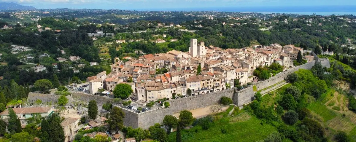
Perched on a rocky spur and surrounded by ravines, Tourrettes-sur-Loup is a true medieval gem. It’s stood strong through centuries of invasions. Today, it proudly shows off its defensive roots, a sun-washed row of houses that cling dramatically to the cliffside, forming a stunning natural wall. Rebuilt in the 15th century, the village has kept all its old-world charm, with two fortified gates, cobbled lanes, and a massive château around which the town is built.
Artists couldn’t resist the place, and many found inspiration and refuge here. That creative energy shaped a strong cultural identity, which still shines through the galleries, studios, and artistic events that fill the village.
Just a short walk from the center, in the La Ferrage area, you’ll find the Bastide aux Violettes, a living museum dedicated to 150 years of violet-growing history. Housed in a 19th-century farmhouse, it’s full of displays, old tools, and even greenhouses where they grow violets on clever vertical beds, the village’s floral emblem.
Above the village, the Saint-Jean chapel offers a view over the landscape. Inside, you’ll find simple, heartfelt frescoes showing scenes of rural life and violet harvesting, a lovely tribute to the spirit of Tourrettes.
Secretive yet vibrant, Tourrettes-sur-Loup wins you over with its authenticity, rich heritage, and creative soul. It’s a must-see stop between the sea and the mountains.
Food Market
Wednesday mornings
⚙️ Info (Tourist Office Website)
Saturday mornings
⚙️ Info (Tourist Office Website)
Cabris
Altitude 550m (1800ft)
To Coast 15km (9.3mi)
Perched high up, Cabris overlooks a sweeping view of the Côte d’Azur and offers one of the most breathtaking panoramas in the region. From the village heights, you can see all the way from Nice to the Estérel, with the Saint-Cassien lake nestled in between, a stunning mix of sea and forested hills.
At the heart of the village, things come alive around Place Mirabeau. Visitors also love the walk up to the ruins of the old feudal castle, the village’s highest point, where the 360° view is absolutely incredible. This commanding spot didn’t go unnoticed by famous writers, Albert Camus, André Gide, and Antoine de Saint-Exupéry all came here seeking inspiration and calm.
With its quiet little streets, jaw-dropping setting, and thoughtful, literary vibe, Cabris is a stop full of character, discreet and precious, tucked between the scents of Grasse and the bright skies of the Mediterranean.
Food Market Friday mornings
⚙️ Info (Tourist Office Website)
Mons
Altitude 810m (2660ft)
To Coast 26km (16mi)
Mons is a hilltop village that opens up onto an extraordinary panorama of the region. On a clear day, you can even catch a glimpse of the Corsican peaks, a rare, dizzying sight. The village has kept a strong medieval feel, with a 13th-century church, narrow little streets with charming names, vaulted passageways, wrought-iron signs, and roofs weighed down with stones to resist the mistral winds, all signs of a tough, vibrant rural past.
But Mons isn’t just about the Middle Ages, it’s also a prehistoric site. A Megalith Trail takes you to no fewer than 11 ancient monuments, including the Riens dolmen, just 1.5 km from the village. With two large arched stones and a burial chamber, it shows just how far back human presence goes in this area.
With its end-of-the-world feel, rich heritage, and unforgettable views, Mons captures the very essence of a Provençal village, hanging somewhere between history and the sky.
Food Market Sunday mornings
⚙️ Info (Tourist Office Website)
Châteaudouble
Altitude 500m (1640ft)
To Coast 31km (19mi)
Châteaudouble is a tiny hamlet clinging to the cliffside, overlooked by an old watchtower and facing dramatic gorges. It’s a truly remote spot, the road leading there was carved straight into the rock and wasn’t even built until the 19th century. The village keeps a friendly, down-to-earth vibe, especially around the charmingly named Place du Purgatoire.
With its dizzying gorges, quiet little streets, hidden heritage, and end-of-the-world feel, Châteaudouble is best explored slowly, taking it all in with a sense of calm and wonder.
Food Market Friday mornings
⚙️ Info (Tourist Office Website)
Fayence + Tourettes
Altitude 350m (1150ft)
To Coast 23km (14mi)
Fayence
Fayence is one of the most beautiful villages in the Var backcountry and still holds tight to its authenticity. Its charming, tangled streets are perfect for a stroll, from the fortified gate from the 14th century, to the old communal oven, the 18th-century parish church, and up top, the Clock Tower with its graceful wrought-iron campanile. From there, you get a sweeping view over the surrounding plain, often dotted with gliders drifting silently overhead, Fayence is actually one of the top gliding spots in France.
The village also has a lively, welcoming vibe. Every week, its markets, especially the Saturday one, which is the biggest, bring together local producers, visitors, and regulars.
In Fayence, everything invites you to slow down and enjoy that laid-back southern lifestyle, right where tradition meets the gentle rhythms of the Provençal countryside.
Food Market Tuesday, Thursday and Saturday mornings
⚙️ Info (Tourist Office Website)
Tourettes
Tourrettes, often overshadowed by its neighbor Fayence, is still much worth your attention. Perched on a hill and full of charm, it stands out thanks to its artistic vibe. As you wander through its gently sloping streets, you’ll come across all kinds of artworks, turning the whole village into an open-air gallery for anyone strolling by.
Villecroze
Altitude 330m (1080ft)
To Coast 42km (26mi)
Tucked just below Tourtour, Villecroze-les-Grottes has a lively, down-to-earth feel that sets it apart from some of the more polished villages around. Its old center looks straight out of a postcard, with picturesque alleys lined with arches and vaulted passages, and the village clock tower welcoming you right into its soul. Rue de France is especially photogenic, with one covered passage after another.
But what really makes Villecroze stand out are its strange and fascinating troglodyte caves carved into the tuff cliff at the village entrance. Fortified in the 16th century by a local lord, these natural cavities now take you through a surprising mix of stalactites and Renaissance touches, like mullioned windows looking out over the landscape, and even a hidden watchtower behind a waterfall. All of this sits right next to a leafy, flower-filled park.
In Villecroze, heritage, nature, and friendliness all come together in a simple, easygoing way, making it a peaceful and curious little stop worth exploring.
Food Market Thursday mornings
⚙️ Info (Tourist Office Website)