OVERVIEW
Table
| Name | Appeal | Peak in m (ft) | |
|---|---|---|---|
| 1 | Mercantour | ✦✦✦✦✦ | 3143 (10314) |
| 2 | Verdon | ✦✦✦✦✦ | 1930 (6333) |
| 3 | Estérel | ✦✦✦✦✧ | 614 (2014) |
| 4 | Préalpes d'Azur | ✦✦✦✧✧ | 1778 (5833) |
| 5 | Ste-Baume | ✦✦✦✧✧ | 1148 (3766) |
| 6 | Maures | ✦✦✧✧✧ | 776 (2546) |
Map
Click on the icon ![]() in the top-right corner to view the map in full screen.
in the top-right corner to view the map in full screen.
The mountains ranges are in the 7th layer.
They are outlined by white contours, with their highest peak marked by a black dot and other peaks by white dots.
Show or hide the other layers as needed.
MOUNTAINS RANGES
Mercantour

Appeal ✦✦✦✦✦
Full Name
Parc National du Mercantour
Highest Peak 3143m (10,314ft) 📍Cime du Gélas
The Mercantour is a one-of-a-kind place tucked away in the far southeast corner of the French Alps, where the mountains practically dip into the Mediterranean. It’s one of the wildest and best-preserved national parks in France, a natural treasure full of snowy peaks, deep valleys, crystal-clear streams and little villages clinging to the hillsides.
The park’s made up of seven main valleys, like the Tinée, Vésubie, Var, Cians, Roya and Bévéra, and the variety of landscapes is pretty amazing. You’ve got the red gorges of Cians and Daluis, which look a bit like the canyons in Colorado, mixed in with larch forests and blooming alpine meadows. Along the trails, you might bump into ibexes, chamois, marmots and if you’re lucky, you could even catch a glimpse of a golden eagle or a bearded vulture.
Right in the heart of the area, there’s the Vallée des Merveilles, up near Tende, which is one of the biggest open-air rock art sites in Europe. There are over 40,000 prehistoric carvings there, more than 5,000 years old, etched into the rocks at the foot of Mont Bégo. Hiking through this valley, or the nearby Fontanalba one, gives you this mix of raw natural beauty and ancient art. To keep the place protected, you can only check out the carvings with a guide.
Then you’ve got Saint-Martin-Vésubie, a small mountain town they call “the Swiss village of Nice”. It’s a great base to explore the park from, and it’s also where loads of outdoor adventures start, like via ferrata, mountain biking, tree climbing and canyoning. There’s even the Alpha center there, all about bringing wolves back to the area.
Whatever the season, Mercantour pulls you in with its authenticity, jaw-dropping views and rich wildlife. Whether you’re into hiking, just soaking up the scenery, diving into some culture or getting your adrenaline fix, it really does feel like you’ve reached the edge of the world.
Verdon

Appeal ✦✦✦✦✦
Full Names
Gorges du Verdon
Parc Naturel Régional du Verdon
Highest Peak 1930m (6,333ft) 📍Mourre de Chanier
The Gorges du Verdon make up a stunning 20-kilometer-long canyon, and it’s actually the biggest one in Europe. It’s this jaw-dropping natural chasm, with cliffs shooting up to 600 meters high, where you get this crazy mix of towering rock walls, scattered boulders, hanging forests and the turquoise twists of the Verdon River down below.
Over thousands of years, erosion carved out the canyon, and now thanks to two dams that control the water flow, you can actually hike all the way down into it.
There are loads of hiking trails that run along the top edges of the canyon. They take you along cliff sides, through woods, over rocky sections and to these incredible lookout spots. Whether you’re going for a short walk or a full-on trek, you really get to feel the canyon’s full, dramatic scale.
If you’re driving, the roads that follow the canyon give you just as many insane views. They got a bunch of scenic stops where you can pull over and take in the kind of views that’ll stick with you forever.
Since 1997, the gorges have been part of the Verdon Regional Natural Park, which helps keep the area protected. There’s a rich variety of wildlife: trout, carp and pike in the water, and griffon vultures soaring overhead.
At the bottom end, there’s the Sainte-Croix Lake, glowing in shades of emerald and turquoise. It marks the entrance to the canyon and brings a calm, peaceful vibe after the raw, rocky wildness of the gorges. You can swim there or paddle your way into the first curves of the Verdon.
The Verdon, with its sheer size, untouched nature and endless activities, is honestly one of the most powerful and majestic gems in southeastern France.
Estérel
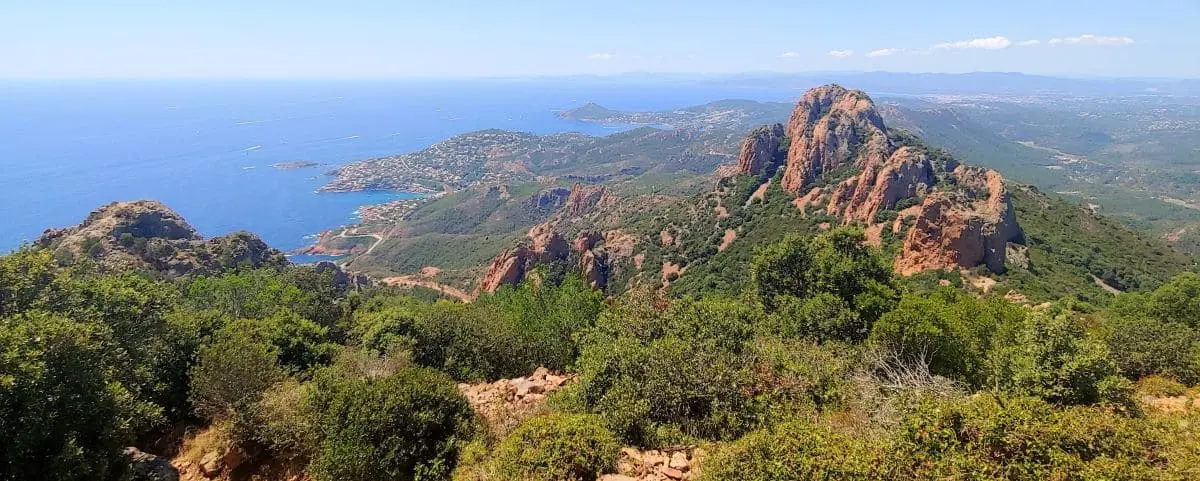
Appeal ✦✦✦✦✧
Full Name
Massif de l’Estérel
Highest Peak 614m (2,014ft) 📍Mont Vinaigre
Just a stone’s throw from Cannes, the Estérel Massif offers a breathtaking escape where sky, sea, and fiery red rock come together. This ancient volcanic range, ripped from its original base during the formation of the Mediterranean, unfolds a dramatic landscape of jagged ridges, steep cliffs, dense forests, and fragrant scrubland. But what really grabs you first is the color, deep, glowing shades of red and orange that pop against the intense blue of the sea. The contrast is just stunning.
To really take in the full beauty of the Estérel, though, you’ve got to head inland and gain some altitude.
Not far from the coast, the Pic de l’Ours is one of the massif’s most iconic peaks. You can hike up to it on gorgeous trails, and once you’re at the top, the view is unforgettable, you’ll see the whole coastline laid out before you: the Estérel hills, the Lérins Islands, the bays of Cannes and Saint-Raphaël, and on a clear day, even the Mercantour mountains or Corsica in the distance.
Close by, the Dent de l’Ours adds to the drama. This razor-sharp ridge, bristling with jagged red rocks, looks wild and sculptural, like nature’s own art installation.
Between the two, the trails wind through classic Mediterranean vegetation, holm oaks, Aleppo pines, heather, rockrose, and mastic trees, filling the air with resinous scents and salty breezes. The stillness, the light, and the sweeping views make this a dream spot if you’re into hiking, photography, or just getting a deep breath of fresh air.
Préalpes d'Azur
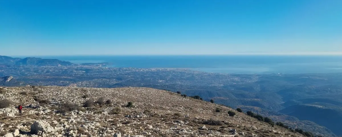
Appeal ✦✦✦✧✧
Full Name
Parc Naturel Régional des Préalpes d’Azur
Highest Peak 1778m (5,833ft) 📍Montagne du Cheiron
Just over an hour from Cannes, the Préalpes d’Azur show you a completely different side of the Côte d’Azur, quieter, wilder, and way more authentic. This area, now a designated Regional Natural Park, feels like a giant balcony between the sea and the mountains, with deep valleys, limestone plateaus, panoramic ridgelines, and untouched little villages. Out here, glitter gets swapped for hiking boots, crowds for sheep, and palm trees for oaks and lavender. It’s your chance to discover a higher-altitude Provence that still flies under the radar.
At the south of the park, the mountains above Tourrettes-sur-Loup offer stunning views and a real sense of being immersed in nature. Two main peaks define the skyline: the Puy de Tourrettes and the Pic des Courmettes.
The Puy de Tourrettes, standing over 1,200 meters high, looks like a huge limestone wave rising above the coast. The hike takes you through alpine meadows sprinkled with wildflowers in spring, and you’ll get sweeping views almost from the start. At the top, the panorama is incredible: to the west, the wooded hills of the Grasse backcountry; to the south, the sparkling Mediterranean all the way to the horizon; and to the north, the snow-capped peaks of the Alps, even when it’s not winter.
A bit further south, the Pic des Courmettes gives you equally jaw-dropping views. Perfect for spotting high-altitude Mediterranean plants and wildlife, the trail climbs through oak and pine woods, then opens onto a wide plateau where the summit stands tall. From up there, you can look out over the coastline from Nice to the Estérel, and on a super clear day, you might even catch a glimpse of Corsica.
You can spot both these peaks from the coast, they’re a dramatic backdrop to the whole region. But they’re more than just pretty scenery: they’re also amazing hiking spots if you’re craving peace, open space, and epic views. In the Préalpes d’Azur, you realize that the Cannes backcountry, so often overlooked, is totally worth the trip on its own.
Sainte-Baume
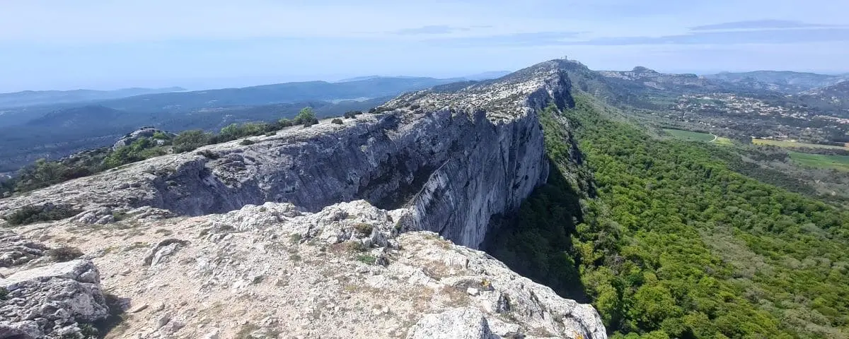
Appeal ✦✦✦✧✧
Full Names
Parc Naturel Régional de la Sainte-Baume
Massif de la Sainte-Baume
Highest Peak 1148m (3,766ft) 📍Joug de l’Aigle
The Sainte-Baume massif rises like a huge rocky wall, topping out at over 1,100 meters. It’s a real cool oasis, home to one of the oldest and best-preserved forests in all of Provence. Deep and shady, it’s packed with white oaks, beeches, yews and maples.
But this place isn’t just a natural gem, it’s also full of spiritual meaning. It’s closely tied to Mary Magdalene, who’s said to have lived as a hermit in a cave tucked into the cliffside, around 950 meters up. Since the Middle Ages, that cave’s been a pilgrimage site. You can only reach it on foot, walking through the ancient forest that shelters you from wind and sun, in this quiet, almost sacred atmosphere. The climb itself feels meditative, with tall trees all around and the soft rustle of leaves underfoot.
Once you get to the top, the view really opens up. From the ridge, you can see all the way to the sea on one side and the Alps on the other. The cliffs stretch out in a long limestone ribbon, perfect for hiking. Up there, it’s totally peaceful, just the sound of the wind or the flap of a bird of prey’s wings.
The massif also keeps traces of its old practical uses. You’ll come across ancient ice pits: big stone wells where people used to store natural ice collected in winter. That ice was then hauled down to nearby towns.
Sainte-Baume is a place for slow walks, for quiet, for wonder. A mountain full of character, wild and spiritual.
Maures
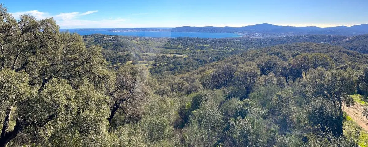
Appeal ✦✦✧✧✧
Full Name
Massif des Maures
Highest Peak 776m (2,546ft) 📍Signal de la Sauvette
The Maures massif stretches for about sixty kilometers between Hyères and Fréjus, with its dark, thick forests covering rolling hills. Its name comes from the Provençal word “mauro”, meaning “dark,” a nod to the deep shades of its oak and chestnut trees.
This mountain range stayed pretty isolated for a long time and wasn’t really accessible until the late 1800s.
The highest point in the massif is 780 meters, and from up there, the forested peaks give you stunning views over the Gulf of Saint-Tropez, the Mediterranean and the Îles d’Or. One of the best hikes takes you up to the Notre-Dame-des-Anges chapel, perched on a ridge with views that stretch all the way to Porquerolles on a clear day. Whether you’re on the ridgelines or tucked away in the woods, the Maures offer a real wild nature experience, with stripped cork oaks, forgotten trails and quiet wildlife.
To the north, the Maures plain connects the schist landscapes of the massif to the limestone plateaus further inland in Provence.
And then, between land and sea, the massif literally drops into the Mediterranean, forming the Corniche des Maures, a scenic road clinging to the cliffs between Bormes-les-Mimosas and Cavalaire. It overlooks white coves and wooded capes, where the forest almost dips its toes into the waves. This stretch of the Côte d’Azur is still pretty unspoiled, and it feels like nature and sea are holding hands.